Joe's Story - February 2002
The next and final trip almost proved to be my undoing. Danny was
supposed to be on this trip across the Copland Pass with me, but he
very wisely pyked to avoid an almost certain death. The Copland Pass
is a bottom-end mountaineering trip with a traverse down a steep
glacier which is fully bergschrunded and crevassed. It is a daunting
prospect for a tramper, especially for someone travelling from the
west-east direction which added 1,000m of climb to the trip and
potentially fatal navigational booby traps.
The first lag was an easy 4-hours into Welcome Flat. This is a
magical spot right under the Sierra Range which towered more than
2,000m above and spilled glaciers from the skies. And what's more,
there are natural thermal springs right there amidst the alpine
grandeur! I spent about an hour and a half in the hot pools chatting
with some American mountaineers who tried for Copland Pass but got
to Fitzgerald Pass instead and almost killed themselves. That was a
great confidence booster of course. After dinner I couldn't bear
going to sleep when the stars were out in force shinning at us, so I
just sat around the hut admiring them and tried to learn Dutch and
improve my German. I will have some animals to play with when I visit
Europe next year as the chief scientist of the Dutch national wildlife
reserve took a rather strong liking of me. We stayed up and chatted
until well past 1 a.m. about life and all that general guff.
This almost proved fatal. Due to very little sleep in the last two
days and the tranquillity of the bivvy, I woke up very late and
didn't get going until 12:30pm the next day. In sweltering heat, I
did not make the 1,800m climb up to Copland Pass until after sunset
when the Copland snowfield froze. This was a very bad place to be at
a really bad time. I made a difficult decision to descend the eastern
ice face in semi-darkness, on my own and without mountaineer equipment
except my ice axes and crampons. Were the situation to arise once
again, I think I would still make same decision. But it was just a
most imbecilic thing to be on Copland Pass at that time of the day,
something I hope I'll never be stupid enough to do again.
I can only say I am lucky to be alive. Half way down the ice face
as I was front-pointing down (which I hadn't done for 6 years since
I learned it), one of my crampons slipped because my boots were
disintegrating and my soles were splitting apart. How I got out of
that one alive I don't know, except I somehow half-fell down the
vertical ice face into a crevasse where I adjusted the crampons.
Further down the snowfield I slipped and fell for about 7 metres.
Now I have not done any self-arresting ever since I learnt it in
beginners' snowskool in 1996. I had no chance to practice it and
only rehearsed it in my mind. However, my survival instinct kicked in
and I did a perfect self-arrest. I was in a mental state where the
only thing that concerned me was survival, I anticipated the fall to
happen and I took no prisoners in executing the self-arrest. Just as
well. Another 10 metres further down would have been a vertical ice
face with a series of crevasses which would have certainly proven to
be my grave.
It must have been about 10:30 or 11:00pm when I left the last patch of
ice and climbed the rocks to Copland Bivvy in almost pitch darkness.
Every step in the last hour was knocking on death's door, and had
I died there, I would simply have been a missing person as no one
knew where I was. By the time I reached the beloved Copland Bivvy I
was completely exhausted, mentally and physically, with ~11 hours of
tramping that day, 1,800m ascent up treacherous rotten rocks on the
west with a heavy pack, 250m of front-pointing down a glacier and two
near-death episodes. I was in full crisis-management mode on the
glacier, just being completely logical, calm, concentrating on every
move down the ice, appraising my situation constantly and keeping
emotions completely out. But when I reached the bivvy, I laid in a
heap on the bivvy floor shaking uncontrollably for a long while before
gathering enough strength to cook dinner. This is an experience I
never want to repeat again, and it has inspired me to learn more
mountaineering so I am more apt to deal with alpine situations.
After dinner I sat in front of the Bivvy, staring Mt. Cook who
stood silently across the mighty Hooker Glacier, her snow-capped
summit and glaciers glistening under the midnight moonlight. It was
an absolutely magical spot and I was just speechless. There are
glaciers, ice, snow and moraine coming at me from left right and
centre. It's absolutely indescribable. I was just in constant awe
of the majesty engulfing me. I would still prefer the wilderness of
Fjordland to Mt. Cook, but it was just such an overwhelming sight and
I had photos of Mt. Cook in every mood - first ray of sun rise on
the summit, last ray of sun set on the summit, against cloudless sky,
against amazing cloud formations, in darkness against a multitude of
stars, against fiery clouds foreshadowing an impending storm. It was
a foreign but mind-blowing place, and completely inspiring.
Comparing my ordeal down the icefield, the treacherous Copland Spur
was faint in comparison and I made it down the daunting Hooker moraine
wall without too much hassle, although I could see why many people
would break down and cry. There were many moments when I wondered how
I was going to get down alive, but I eventually found a way, and the
Hooker Glacier was pretty easy to negotiate.
Note by Danny: having gone around the Southern Alps the long way
(by bus, via Haast Pass and Wanaka), I ran
into Joe at Mount Cook, on the morning after his trip.
|
Route Description (West to East)
All the route descriptions I have gathered so far have been from Mt. Cook
Village to West Coast. The hut books in the area confirm this: there
are scarcely any successful crossings west to east. If you can, do it
east to west - not only do you save navigation hassles and 1000m of
climbing, but you also get a hot spring at the end and 40 backpackers
marvelling at your staunchness. However, if you HAVE to do it west to
east, I believe these notes will be quite useful. If you survive
without injuries, you will not regret having done the route.
Bring an ice axe and crampons, and know how to use them. Rope and
glacier extraction gear are recommended if you can be bothered carrying them.
- Highway to Welcome Flat: This is straight forward, albeit with some
avalanche spots in winter. Average time is between 4-6 hours. If you
can't do it under 6 hours, question your fitness for the day ahead.
- Welcome Flat Hut: Warning for those who do not like crowds: the hut is
very popular during summer, full every night with 30-50 backpackers who
come in for a night in the hotpools. However the nearby bivvy provides
cool and quiet accommodation, if you can put up with the sandflies and
possums.
- Welcome Flat Hut to Douglas Rock Hut: Straight forward track, but
during times of extreme heavy snow this route can have avalanches.
Beyond Douglas Rock Hut the route is constantly swept by avalanches.
- Douglas Rock Hut to Copland Pass: The route is well marked by cairns
as it sidles up the side of Copland Valley. However, after it climbs
up past a gorged waterfall and leaves the main Copland Valley into the
side basin below Copland and Fitzgerald Passes, the cairns disappear and
navigation becomes difficult in times of poor visibility, which is quite
a common phenomenon.
Suitable campsites in the side basin can be found. One is about 100m
about the waterfall in the gorge. Soon above the waterfall, the
snowgrass fields disappear and the ground is very rocky with broken
schist everywhere in summer (and of course blancket of snow and
avalanche debris in winter). However, there are a couple of suitable
campsites further up, at the lower end of a couple of large snowfields
where small patches of flat sandy ground could be found and you can melt
snow for water. The last such suitable place is about 300m below the pass.
The biggest pitfall crossing west-east is navigation up to the Pass.
The problem is avoiding getting to Fitzgerald Pass. Fitzgerald Pass and
the little pass 300m north-west of it (737239) look much more like
passes from the west but should be avoided. There has been several
fatalities in the area, as Fitzgerald Pass is impassable without full
alpine climbing gear and even experienced climbers have difficulty
descending it. There are false cairns leading up to both these (im)passes.
Copland Pass does not look like a pass: it is not the lowest point on the
Main Divide. Instead, it consists of several gaps in the jagged sky
line north of the little pass at 757239. Aim for one of these gaps up
very eroded and treacherous schist. You will be rewarded by a
magnificent view of Mt. Cook when you gain the pass.
- Copland Pass to Copland Shelter: This section is most interesting in
late season (February) as the snowfield consolidates into hard ice and
crevasses open up. As there is no avalanche danger, doing this section
in mid afternoon will increase the chance of finding some soft snow
under your crampons.
Find a suitable place to gain the Copland snowfield. This is easier
said than done. Large burgschrunds run across the snowfield and if you
fall in without glacier extraction equipment you can be in for some
serious trouble. Once on the snowfield, there is a rocky spur on your
right (south), linking the Main Divide to Hooker Morraine Wall. We'll
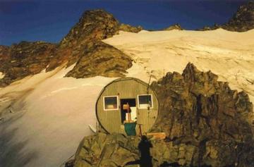
call this the Copland Spur. Look for Copland Shelter: it should 200
metres below on Copland Spur, with conspicuous orange paint. If you
cannot see the Shelter and you are on 70 degree vertical ice, ponder on
your navigation.
The way down to the Shelter is on the snowfield next to Copland Spur.
On the flat top of the snowfield, walk south and approach the spur.
Then proceed down on the snowfield, front-pointing, negotiating
crevasses. After 200 metres, the spur flattens and is covered by snow.
Walk on the snow-covered spur towards the Shelter, crossing over to
the Fitzgerald side. Walk on the edge of the snow until you hop off the
snow up to the Shelter which is a welcome relief and a fantastic place
to contemplate life under awe-inspiring Mt. Cook.
- Copland Shelter to Hooker Glacier: Do NOT attempt to cross the gut on
the right under Fitzgerald Pass to gain Hooker Hut. There has been a
landslide in the gut and every year several people break a few limbs
trying to negotiate the gut. Do not attempt the gut on the left under
Copland Pass either - you'll understand why when you get there. The way
to go is to stay on the very tip of the ridge all the way down to the
Hooker Glacier morraine wall. It may seem impossible and sometimes it
is tempting to stray towards guts on boths sides. But yes, it is
possible, and staying on top is the only way.
Once on Hooker morraine wall, look for cairns on the northern side,
close to the gut draining Copland Pass. I did not find the morraine
wall too bad, although some climbers tell of stories of people breaking
down crying on the Hooker and Tasman morraine walls.
- Hooker Glacier to Mt. Cook Village: The Hooker Glacier is
covered in morraine at this point and is a stroll in the park to negotiate
compared to your last few hours. Occassionally giant crevasses remind
you that you are actually on a glacier. Walk on the glacier, stay close
to the west side under the western morraine wall, go around Lake Hooker,
and eventually pick up the tourist trail. Most streams on the western
side disappear underground by the time they reach the glacier level.
However, Eugenie Stream is impassable after rain or high snow melt.
Go after your dreams!
|