Parks Rd is a key north-south cycling route through the city centre, as well as part of National Cycle Network route 51, and its junction with South Parks Rd is currently the worst bit of that route. People cycling north are expected not only to share a section of road with high volume traffic flows but to perform an uncontrolled right turn across that traffic; people cycling south are forced to join the main motor traffic flow with no support at all.
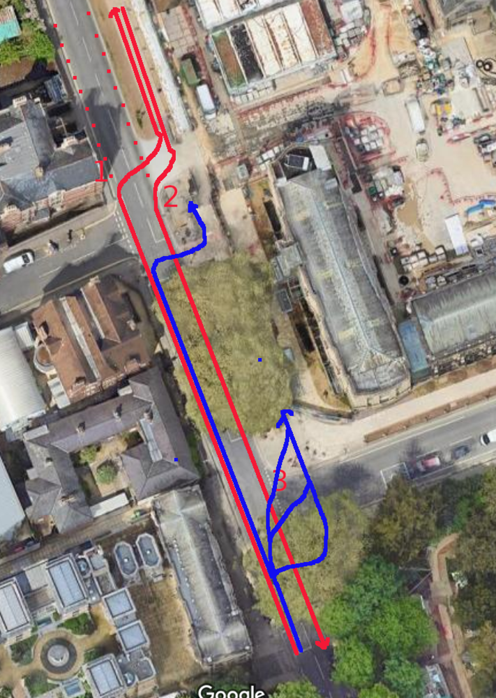
The diagram shows the "official" north-south cycle route in red, making up part of NCN51. The dotted route marks an alternative route, staying "on carriageway" along Parks Rd instead of using the cycle track. There are several reasons people might prefer that: there are problems accessing the cycle track both at the southern end (discussed here) and at the northern end (where access to Banbury Rd from the cycle track isn't really provided for at all); the cycle track is poorly surfaced (with tree roots and drainage problems); and in peak times the cycle track is full of pedestrians.
Northbound
Getting off Parks Rd onto the cycle track (the red "1") is not really provided for at all. There is nothing at all to assist the right turn - and indeed there is no waymarking or signage to indicate that is the route of NCN 51, not even cycle symbols - and this involves turning across two-way motor traffic. Probably the best option is to sit right in the middle of the carriageway, blocking northbound motor traffic, and to wait for a gap in the traffic, but few people cycling have the confidence to do that. When the pedestrian crossing stops motor traffic, southbound vehicles physically block access to the turn off, making this movement impossible.
I have watched this junction for some time and not seen a single person using the "approved" way to get onto the off-road cycle track. Instead, people cycle through the pedestrian crossings to get onto the cycle track - the blue lines show some of the routes I have seen people use. The problem with this is that it can disturb pedestrians, it means that neither drivers nor pedestrians (or indeed other people cycling) have any idea where to expect cycling, and the lack of wayfinding or legibility is disconcerting for anyone encountering this junction for the first time (and as part of the NCN it really should be signposted).
Southbound
For people cycling south on the off-road track, past the museum, there are markings and signs telling them to rejoin the carriageway at the junction with Museum Rd. As usual when the actual infrastructure is broken, almost everyone ignorese these signs.
Rejoining Parks Rd (at 2) either involves merging with moving traffic. People waiting on cycles have no way to triger the pedestrian lights and when the traffic stops for the lights, people cycling end up wedged in either alongside or in front of motor vehicles, the drivers of which may not have seen them entering the carriageway. And the Museum Rd entry sometimes adds additional hazards. People cycling straight on at the junction then risk being left-hooked by cars turning into South Parks Rd (at 3). Note that even just cycling along Parks Rd here is pretty hostile, as the cycle lanes disappear and there are high volumes of motor traffic, well above the LTN 1/20 threshhold for mixing cycling with motor traffic at 20mph.
In contrast, continuing on the footway to the lights and using the pedestrian crossing phase to cycle straight on (with a slight dog-leg, as shown in blue on the diagram) is safe and straightforward. And people are voting for that with their pedals - I do this myself, taking my daughter to school every morning, as do the vast majority of people on the cycle track. In my experience so far (admittedly at 8am when it's pretty quiet) there are no significant clashes with pedestrians; people cycling are on the east of the track and pedestrians (green) on the west, and don't need to cross over one another.
I would be happy with my daughter going through this junction by herself on the second route but not on the first, where I'm making complex judgement calls balancing different kinds of risks.
What to do?
My suggestion is that the way people are continuing southward be regularised, prefering an accessible 8-80 solution to a "confident and assertive cyclists only" one. The short stretch of footway between Museum Rd and South Parks Rd could either be widened and changed to a continuation of the foot-cycle path (the best option) or it could be left as is and changed to shared use.
If the junction is ever rebuilt, the pedestrian crossing across South Parks Rd could be changed to a toucan, perhaps with road markings to direct people cycling to dogleg back onto the Parks Rd (south) carriageway and not to continue on the footway. There would need to be a separate right-turn signal phase from South Rd (south ) into South Parks Rd to support northbound access to the cycle track.