People who think the new low traffic neighbourhoods in Oxford have created exceptional levels of congestion have forgotten how bad traffic was pre-pandemic. To see this, consider the following map, which shows a "cordon" around the Cowley and East Oxford low traffic neighbourhoods. This is taken from the county's Annual Average Daily Traffic Map and the little coloured circles mark traffic count points.
This table shows average traffic (in thousands of vehicles per day) at the various count points on that cordon, for 2018-2019 and for 2023-2024, and the percentage change between those. (I am using those dates for comparison because 2020 and 2021 were during the pandemic and the Cowley and East Oxford LTNs were put in in 2021 and 2022.) more
58% of the children at Cherwell secondary school in North Oxford cycle to school, probably the second highest cycling rate in the UK. In contrast, just 10% of children at Cheney secondary school cycle to school. 41% of children at Larkrise primary in East Oxford cycle to school. In contrast, just 12% of children at Windmill primary in Headington cycle to school. (For the primary schools, "cycling" includes "being cycled".) more
One of the biggest problems with cycling infrastructure in Oxford is that it is riddled with what I call "dual provision", where two bad options are offered to people cycling instead of one good one. This usually means a choice between cycling on the carriageway (and "pretending to be a car") or cycling on the footway (and "pretending to be a pedestrian") and the absence of any space actually allocated to and designed for cycling.
This kind of "dual provision" can occur along main roads, at junctions, and at crossings. It is quite ubiquitous in Oxford, but I look at just three examples: Woodstock Rd, Frideswide Square, and the Barton Park crossing of the A40.
more
Delft has a city centre which is very largely de-motorised. As a result it is a lovely place to walk around and spend time - perhaps the most noticeable thing is just how quiet it is! The core to this seems to be a "low traffic zone" covering most of the city centre, with largely uniform restrictions. Enforcement appears to be by camera. more
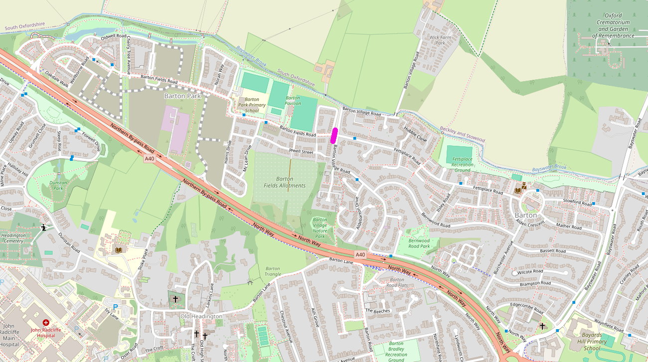
Residents of Barton Park have long-standing concerns with the A40 crossing which connects it with the rest of Oxford, but there are also problems with road danger on Barton Fields Rd, the spine road that runs through the development. This is of particular concern around the primary school, where there have been a number of collisions — fortunately, so far, with walls and cycle parking stands rather than with children.

a possible bus gate location
more
This is an excellent set of ideas. We support both the broader goals of the COMPF project and the list of specific ideas, though the latter will need to be fleshed out with details before we can see how they will actually work. There are also a few areas we would have liked to have seen included that weren't.
The opportunities for improvement are huge. The public realm in the city centre is of quite poor standard, making it relatively unattractive for residents or visitors: central Cambridge is significantly nicer, to make the obvious comparison, as are the centres of York, Bath, or even Birmingham. (Though to be fair, some of those cities are significantly less pleasant than Oxford just outside the centre.)
Walking around central Oxford can be quite unpleasant: narrow, cramped footways, awkward and hostile crossings where people are almost forced to cross on red, too much motor traffic (including high bus flows in some locations), and poor separation from cycling.
There is also poor provision for cycling: most notably in the absence of accessible east-west and north-south routes through the centre, and the lack of any kind of safe, coherent and consistent cycling infrastructure along Banbury and Woodstock Rds.
more
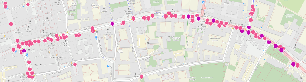
A scheme for High St should be included in the Central Oxford Movement and Place Framework. High St is a major pedestrian corridor, hosts a large number of shops, is a major bus corridor with some of the busiest bus stops in the city, and is a cycle route used by over three thousand people a day.
But High St has never been designed for this mix of uses: it still has pretty much the same layout it had before the bus gate was put in in 1999. It is poor for walking (the footways are too narrow and crossing the wide carriageway with buses blocking visibility can be a real challenge), poor to terrifying for cycling, and far from ideal for bus services, either for bus movement or for passenger boarding and alighting. And the cramped footways and poor visibility can make accessing - or even finding - the shops difficult.
road injuries on High St, 2014-2023
more
This was a response to a consultation on the Greenways. Please let me know of any errors or omissions. more
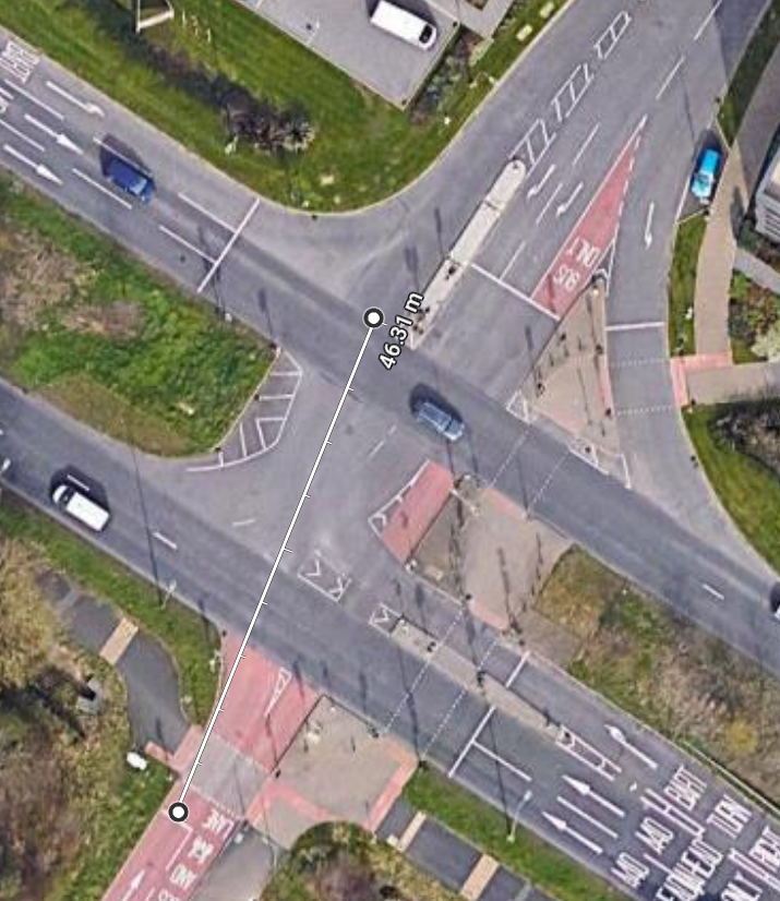
It is 39 metres across the Barton Park junction cycling from Barton Park to Northway, and 46 metres going the other way, measuring the distance from the stop line to the edge of the far-side A40 traffic lane. Analysis of the signal timings reveals that the time allocated for crossing this - the "intergreen" between the green light for buses and cycles ending and the green light for motor traffic on the A40 starting - is the same in both directions, just 8 seconds.
more
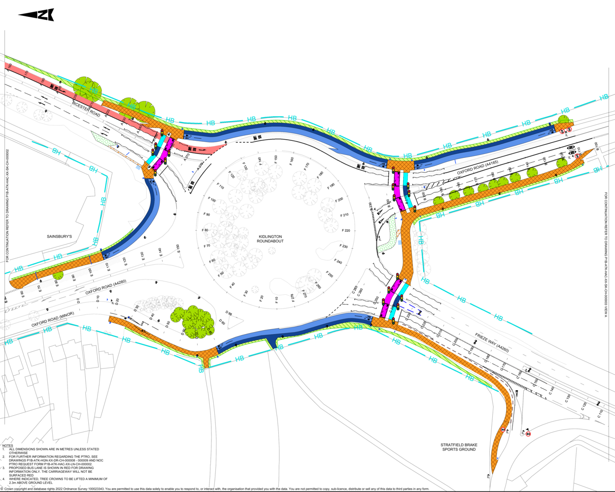
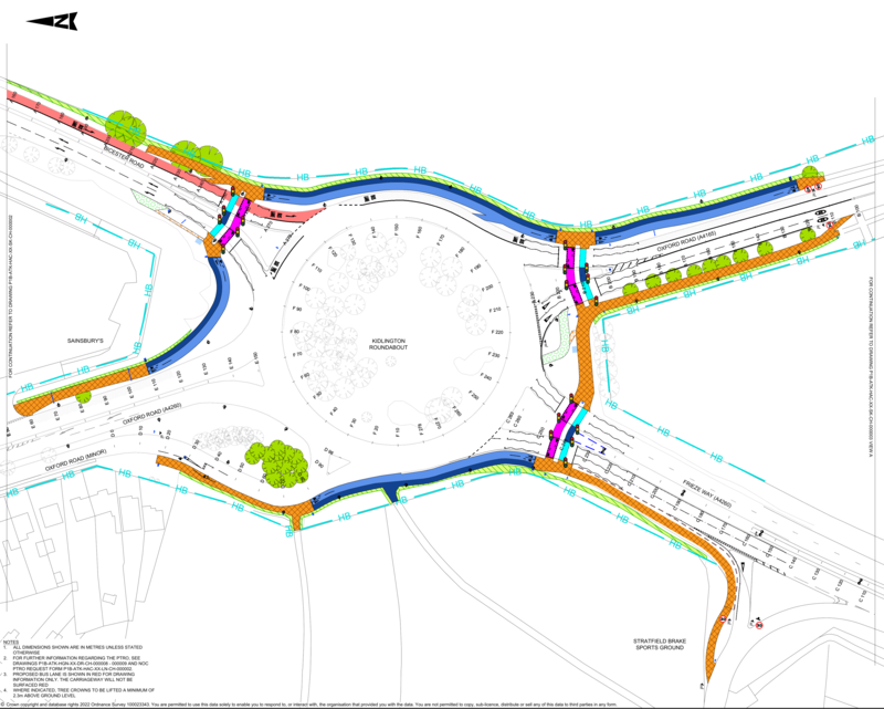
In 2018, Andrew Gilligan wrote "Despite the huge numbers of cyclists using them, Oxford’s main roads and junctions are still laid out almost entirely for the benefit of the motor vehicle". Sadly this remains true, and though a few stretches of road have more or less decent cycling provision along them, there is still not a single Oxford junction actually designed for walking and cycling, rather than having minimal pedestrian provision and ad hoc features to support cycling tacked on as an afterthought. But if we venture a little out of Oxford, there is now one junction whose design really does take walking and cycling seriously, and which could be shown to others as a model. That is the roundabout just south of Kidlington, where Frieze Way and Bicester Rd connect with Oxford Rd.
One of the questions that keeps coming up on social media is "why are there no Low Traffic Neighbourhoods in North Oxford?" Well in fact all of North Oxford consists of low traffic neighbourhoods, with the exception only of Walton St - Kingston Rd, which carries too much motor traffic. (Moreton Rd also carries too much motor traffic for a Low Traffic Neighbourhood, but it is classified as part of the B4495 so at least theoretically its problem is a lack of pedestrian crossings and cycling infrastructure rather than too much traffic — and it is not, in any event, a significant barrier to walking or cycling.) more
There is a consultation on removing the parking on Hollow Way to reduce congestion, with reducing bus delays as the main motivation.
"There are longstanding issues on Hollow Way, where its narrow width coupled with on-street parking create congestion and a safety risk as there is not sufficient space for vehicles to easily pass one another. This is a particular issue for local bus services who regularly use the route and report regular delays. The issue also leads to traffic congestion and makes it more difficult for residents and businesses on the road."
But this illustrates how moto-normative transport planning still is, even in Oxford. The only gains considered are congestion reduction and safety for vehicles, which are balanced against the loss of parking for residents and businesses.
There is no mention of walking, wheeling or cycling, or of Vision Zero; nor are the broader effects on the lives of people considered. There is no discussion of traffic speed, though one of the central concerns with removing the parking is that it will result in people driving faster. And there is no mention of air pollution or noise pollution, which the scheme is likely to make better in some locations and worse in others.
more
I spent four days in Göttingen over the summar, and its transport system makes an interesting parallel to Oxford.
Göttingen is also a university town, with maybe two thirds to three quarters the population of Oxford. It lacks geographical constraints as severe as the rivers are for Oxford, but does have a mountain ridge coming in on the east (and hence only a partial ring-road). It also has narrow medieval streets (it wasn't that badly bombed during the war). And it has high cycling rates and a public transport system that is largely dependent on buses -- there is no tram or metro system, and as with Oxford the railway system serves longer distance trips.
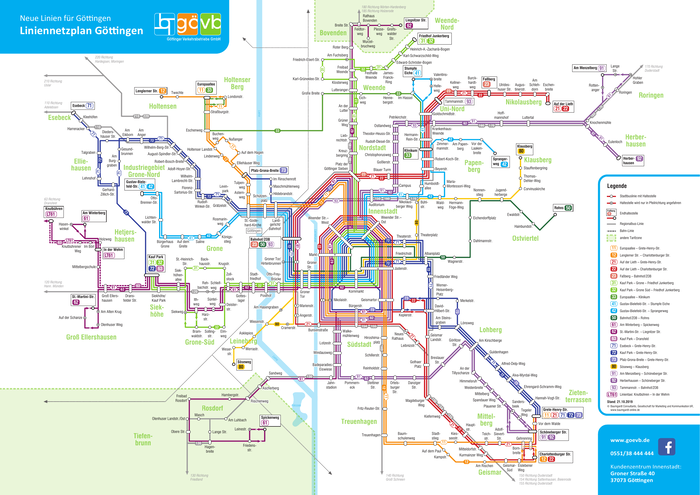
Göttingen bus network
more
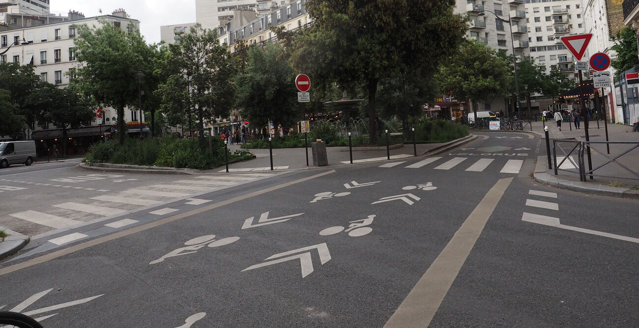
In Britain the term "cycle street" is not well known and there seem to be few implementations. I am talking about what the Dutch call a fietsstraat, the French a vélorue and the Germans a Fahrradstraße; a "bicycle boulevarde" in the United States.
Here is the clearest explanation I can find, translated from Guide des Aménagements Cyclables:
A cycle street is a street that accommodates transit bicycle traffic and only local motorized traffic. In some countries, a cycle street is defined by regulations and may, for example, prohibit overtaking (Belgium), or authorize several people to ride abreast (Germany). In the Netherlands, it has no regulatory basis, but is the subject of specific recommendations:
- cycles must be able to take over the carriageway: this is the case regardless of the volume of cycles as soon as motorized traffic is less than 500 vehicles per day. Ideally, cycle traffic is at least twice as high as motorized traffic, with a limit for the latter set at 2,000 vehicles per day.
- the cycle street has priority at intersections over cross streets.
- the roadway has the same surface as cycle paths (red asphalt in the Netherlands).
So, a cycle street is a low traffic, low speed street with a lot of cycling on it, optimised for cycling priority, comfort, speed, wayfinding, etc. It needs to be designed to either prohibit (Germany and Belgium) or deter motor vehicles from overtaking people cycling.
To be useful I think a cycle street needs to be of reasonable length, to allow people cycling to relax for a significant amount of time. Adding just 100 metres of differentiated "cycle street" to a route may add more complication (and thus cognitive burden) than leaving it as an ordinary low traffic street. So for Oxford I only consider routes at least half a kilometre long.

Rue de Charenton, Paris - vélorue
more
Paris has been radically reallocating space from motor vehicles to cycling and public space. The most visible changes are the dramatic cycle tracks (Rue du Rivoli, etc) and the space reallocation (Place de la Bastille, etc). But there are less visible changes that are just as important, in particular low traffic streets and circulation system changes. And the political and legal and design context of these changes is important.
This is based on three days I spent in Paris in May 2024, as part of a London Cycling Campaign study tour. One day involved discussions with the deputy mayors in charge of transport for the 14th and 20th arrondissements and a presentation on the VIF "Ile-de-France cycle network" (with some cycling to get to the meetings); a second day involved cycling around looking at infrastructure, guided by campaigners from MDB and Paris en selle; and I had two half-days largely spent walking around by myself.
more
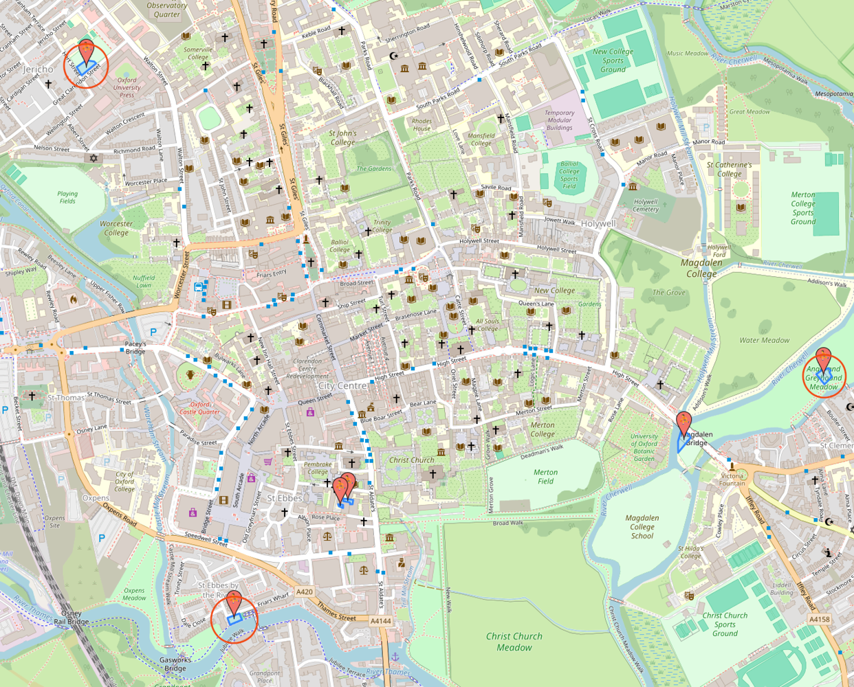
Central Oxford lacks any kind of playground, or even any kind of public "run around" green space. Twice I have been stopped by tourists and asked where they can take their children to play. Lots of residents tell me they would spend more time in the city centre if they had somewhere they could let their kids run around in between shops or museums.

the three nearest playgrounds are circled; the ones identified by Open Street Map at the Story Museum and inside Magdalen College School are not public
The nearest public playgrounds are quite some way away. From Carfax, Friars Wharf is 900m, Great Clarendon St 1.3km, and Angel and Greyhound Meadow 1.6km. All of these require dealing with at least one main road; none of them have public toilets or baby-changing facilities. The grassy area outside the Natural History Museum offers some "run-around" space, but that's still a kilometre from Carfax. more
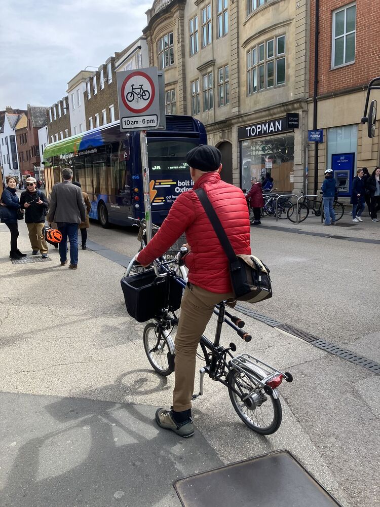
The photo shows a friend of mine. He can and does cycle long distances, and he can walk with crutches, but he can't dismount and push his bike. At least half a dozen women, including my sister, have told me that they could comfortably cycle in late pregnancy when they couldn't walk any distance.
more
There have been concerns about road danger on Barton Fields Rd, the spine road that runs through the Barton Park development on the eastern outskirts of Oxford, in particular around the primary school. One driver ploughed into the cycle parking stands outside the school, another hit one of the buildings under construction on the other side of the street, and there are a lot of other incidents that don't show up in the official road injury record. (There are also concerns about road danger at the crossing of the A40; I have written about those elsewhere.)
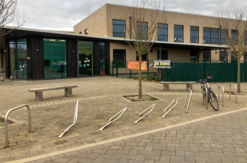
cycle parking stands outside Barton Park Primary School, bent over by being driven into
|
more
Parks Rd is a key north-south cycling route through the city centre, as well as part of National Cycle Network route 51, and its junction with South Parks Rd is currently the worst bit of that route. People cycling north are expected not only to share a section of road with high volume traffic flows but to perform an uncontrolled right turn across that traffic; people cycling south are forced to join the main motor traffic flow with no support at all.
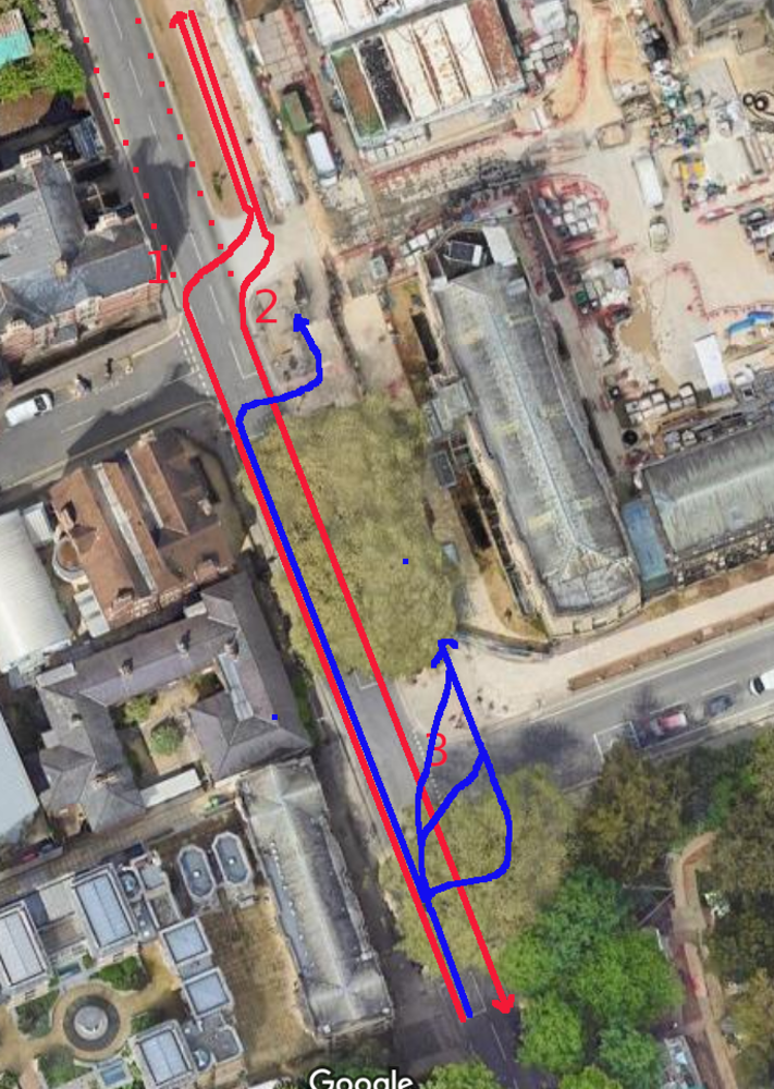
the approved/legal movements are in red and the actual ones (using the pedestrian crossings) are in blue - alternatively, people avoid using the cycle track at all (dashed red)
more
The failure to make Oxford's main roads 20mph is a black spot on Oxfordshire's otherwise successful 20mph speed limit roll out. If one were to pick the roads which need 20mph limits most, it would be roads inside Oxford such as Botley Rd, Woodstock Rd and Banbury Rd, because they have very large numbers of people walking and cycling both along and across them, with clear collision hotspots at pretty much every minor road junction. Making Oxford's remaining roads 20mph is an essential step to achieving both Vision Zero and the county's cycling targets, but it is also the single most effective public health intervention within the county's power. more