Central Oxford lacks any kind of playground, or even any kind of public "run around" green space. Twice I have been stopped by tourists and asked where they can take their children to play. Lots of residents tell me they would spend more time in the city centre if they had somewhere they could let their kids run around in between shops or museums.
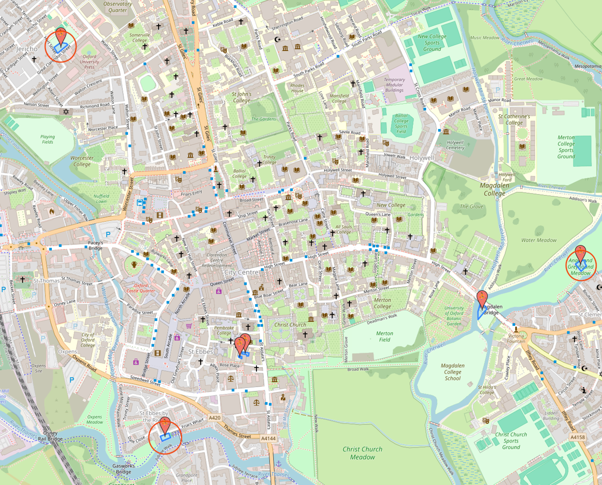
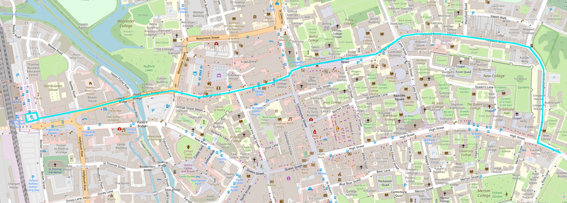
The nearest public playgrounds are quite some way away. From Carfax, Friars Wharf is 900m, Great Clarendon St 1.3km, and Angel and Greyhound Meadow 1.6km. All of these require dealing with at least one main road; none of them have public toilets or baby-changing facilities.

the three nearest playgrounds are circled; the ones identified by Open Street Map at the Story Museum and inside Magdalen College School are not public
When my daughter was small I used to take her into Balliol College and let her run around there. But that was only possible because I worked for the university at the time and because she was relatively quiet and well-behaved.
(more…)
There have been concerns about road danger on Barton Fields Rd, the spine road that runs through the Barton Park development on the eastern outskirts of Oxford, in particular around the primary school. One driver ploughed into the cycle parking stands outside the school, another hit one of the buildings under construction on the other side of the street, and there are a lot of other incidents that don't show up in the official road injury record. (There are also concerns about road danger at the crossing of the A40; I have written about those elsewhere.)
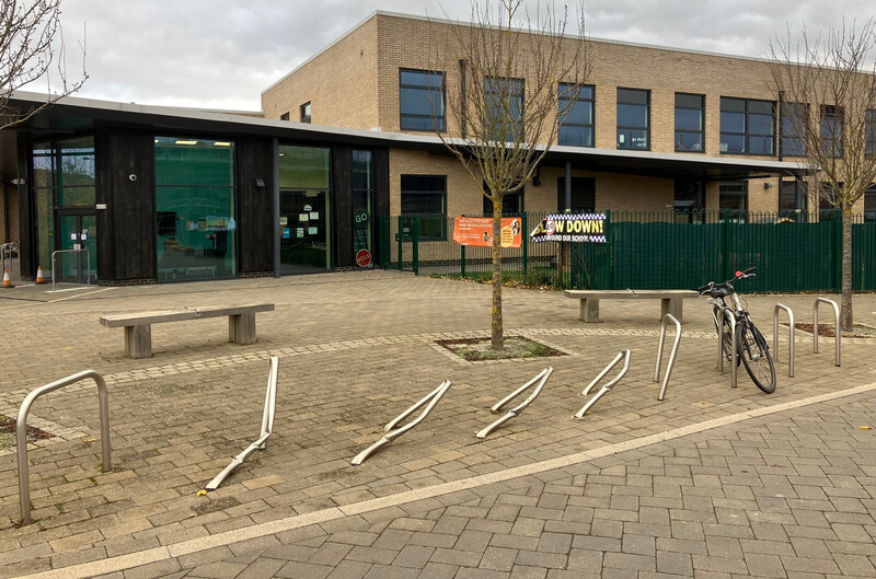
cycle parking stands outside Barton Park Primary School, bent over by being driven into
|
(more…)
Parks Rd is a key north-south cycling route through the city centre, as well as part of National Cycle Network route 51, and its junction with South Parks Rd is currently the worst bit of that route. People cycling north are expected not only to share a section of road with high volume traffic flows but to perform an uncontrolled right turn across that traffic; people cycling south are forced to join the main motor traffic flow with no support at all.
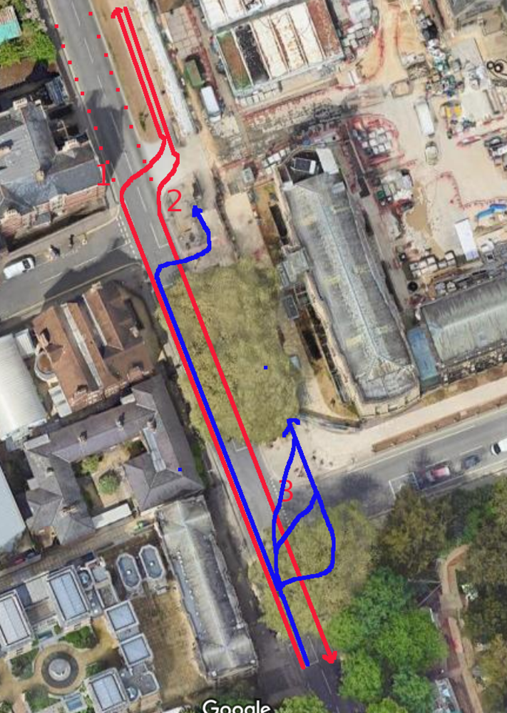
the approved/legal movements are in red and the actual ones (using the pedestrian crossings) are in blue - alternatively, people avoid using the cycle track at all (dashed red)
(more…)
The failure to make Oxford's main roads 20mph is a black spot on Oxfordshire's otherwise successful 20mph speed limit roll out. If one were to pick the roads which need 20mph limits most, it would be roads inside Oxford such as Botley Rd, Woodstock Rd and Banbury Rd, because they have very large numbers of people walking and cycling both along and across them, with clear collision hotspots at pretty much every minor road junction. Making Oxford's remaining roads 20mph is an essential step to achieving both Vision Zero and the county's cycling targets, but it is also the single most effective public health intervention within the county's power. (more…)
"The county should buy a unicorn and stable it on the Plain roundabout, where it will magically stop any collisions, alleviate all congestion, and make walking and cycling safe and accessible to all." This would probably make more sense than some of the transport proposals being bandied about - bus tunnels, removing cycling from main roads, etc. - but here I attempt to address some of the suggestions that seem sensible, but won't do what people want them to do.
Free public transport, segregated cycle tracks, School Streets schemes, traffic calming, Dutch style roundabouts, trams, and so forth are all potentially useful. But they only solve some problems, and in some cases require other measures to make them possible. They are not magically going to obviate the need for traffic removal and reduction - for low traffic neighbourhoods and measures such as traffic filters and the Zero Emission Zone. (more…)
The legal changes to Broad St have been made permanent, but the current layout is clearly still temporary, in the sense that many of the features of the area no longer reflect its actual use. Most obviously, most of the existing kerbs are now redundant, or in the wrong place, and serve only as a trip hazard.
sitting around
A proper plan for Broad St needs to be part of a redesign of the entire area of the city centre north of High St and east of Cornmarket, as envisaged in the Oxford Preservation Trust's proposals twenty years ago, and any such plan will be dependent on funding which is not yet available. But there are possibilities in the management of vehicle access and parking for improvements that could plausibly be implemented in the shorter term. (more…)
The speed limit on Oxford's ring-road (excepting the A34 outside Botley) should be reduced to 40mph and that should be enforced by average speed cameras. This would help with road danger, congestion, community severance and barriers to walking and cycling, noise pollution, air pollution, and carbon emissions. (more…)
At the moment, footways in Oxfordshire fall into the cracks between different county teams. Parking, Road Agreements, Transport Development Control, Active Travel, Maintenance, and different Localities teams all implement or oversee schemes that affect footways, but no one has overall responsibility for them. A single county team should be given responsibility for footways, with a watching brief over all schemes that affect them. That could be a beefed up Active Travel team, or a Parking team with an expanded mandate. (more…)
The Oxfordshire policy on 20mph speed limits says that to be eligible an area must "be within the extent of the built-up environment of the town or village where vulnerable road users and vehicles mix in a frequent and planned manner" and "be in an environment that explains and justifies a lower speed limit to the driver".
A small addition to this would I think make sense. There are sections of road which are not within a built-up area, but which are key walking or cycling links. They may link a village to a bus stop or a strategic cycling route, for example, or an outlying housing cluster (hamlet) to a village centre, or a school to a town centre. Where such sections of road are relatively short and lower speeds would make a significant difference, perhaps because there are no footways or cycling infrastructure, or because crossings are necessary, I think they should be included in the scope of the 20mph policy. (more…)
Guest post by Owen McKnight (Oxford Pedestrians’ Association)
There have been dramatic improvements in infrastructure across East Oxford in the last few years. This is a timeline of specific changes in the OX4 postcode area (which covers East Oxford, Cowley, Rose Hill, Littlemore, and Blackbird Leys). (more…)
No inclusive transport system for Oxford is possible without low traffic neighbourhoods. A genuinely inclusive transport system has to work for everyone. For eight year olds walking or cycling to school by themselves and for four year olds walking or cycling alongside their parents. For eighty year olds who want to be able to walk - or cycle slowly - to their local shops, their GP surgery, or their bus stops, without fear or stress. For wheelchair and mobility scooter users and for the blind and visually impaired. And for everyone else.
Charles St in the East Oxford LTNs, with one mother pushing a child scooting and another pushing a buggy. Car movements are infrequent enough now to make this comfortable. Note that (legal) pavement parking means that neither wheelchairs, mobility scooters, nor larger prams or buggies can fit down the footways.
(more…)
What is the road layout on Oxford's Iffley Rd and how is it supposed to work? The key features here are the use of advisory cycle lanes around a narrow central traffic lane with no centre line; between Donnington Bridge Rd and the Plain the cycle lanes are mostly 1.575m wide and the central lane ranges from 4.66m to 5.93m wide. (This was implemented on Iffley Rd as part of the "Quickways" schemes in 2022. A similar scheme was implemented on Magdalen Bridge in 2020; there the cycle lanes are 2m wide and the central lane is 5m.)

Iffley Rd
(more…)
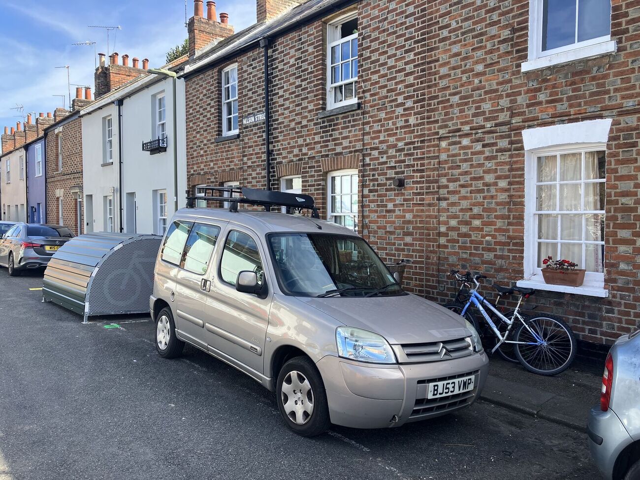
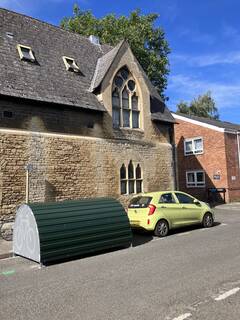
It's great to see Oxford's first cycle hangars appearing in Jericho.
Great Clarendon St
|

Nelson St
|
(more…)
Contra-flow cycling should be allowed on all the one-way streets in Oxford. From LTN 1/20: "There should be a general presumption in favour of cycling in both directions in one way streets, unless there are safety, operational or cost reasons why it is not feasible." (more…)
This outlines a plan for a direct, coherent east-west foot-cycle route across Oxford's city centre. That would run from the railway station across the north of Frideswide Square, along Hythe Bridge St, George St, Broad St, Holywell St, and Longwall St, ending at Magdalen Bridge.
 (more…)
Fixing all the problems with footways and pedestrian infrastructure across Oxfordshire would involve a huge and expensive program of works, which the county doesn't have the resources for. But we need to stop making things worse — current procedures and processes for new transport schemes and developments and ongoing maintenance are progressively destroying our footways. (more…)
Despite the research, I had always downplayed the psychological and social gains from traffic reduction, thinking of them as secondary to health improvements from increased physical activity - and perhaps as a bit "soft" and hard to measure. But my experience with the East Oxford Low Traffic Neighbourhoods has made me rethink this. (more…)
Motor traffic noise pollution is really two separate problems. The first is local spikes in noise from individual vehicles, sometimes deliberately driven - and even modified - to make noise. The second is high levels of ambient noise from motor traffic generally.
Noise pollution is one of the
"invisible problems", often neglected in comparison to the other harms created by motor traffic. Oxford City Council's
noise pollution information, for example, only covers noise from venues, private parties, building works, etc. and doesn't even mention traffic noise. The County Council gets noise complaints logged to FixMyStreet, but appears to have no general information about traffic noise nor any plan or guidelines for addressing it. And noise pollution doesn't feature in
the Low Traffic Future campaign.
(more…)
Deaths and serious injuries — the target of Vision Zero — are just the tip of a much larger iceberg of road danger harm. In addition to the 20 road traffic fatalities and 450 serious injuries in Oxford over the last decade, there were 2800 reported slight injuries (all of those from the STATS19 police database) and (for cycling injuries, across Oxfordshire) ten times as many hospital admissions and attendances (this includes non-collision injuries which are rarely reported to the police). And there will be many minor injuries and collisions which are neither reported to the police nor result in hospital presentations. (Following Ling Felce's death at the Plain, I heard several people make comments like "Oh yes, I've been knocked off my bike twice at the Plain" and "No, I didn't report it either time.") There are even more near-misses and other incidents perceived as threatening. (more…)
Oxfordshire County Council has allocated £8 million to its 20mph speed limit programme (to be spent over three years). But none of that money has been spent - or looks like being spent - in Oxford, even though lower speeds there would have the greatest effect on road danger reduction. (The 20mph speed changes on Iffley Rd, Cowley Rd, etc. were not part of this programme, but were part of the Quickways schemes, funded by the central government Active Travel Fund.) (more…)