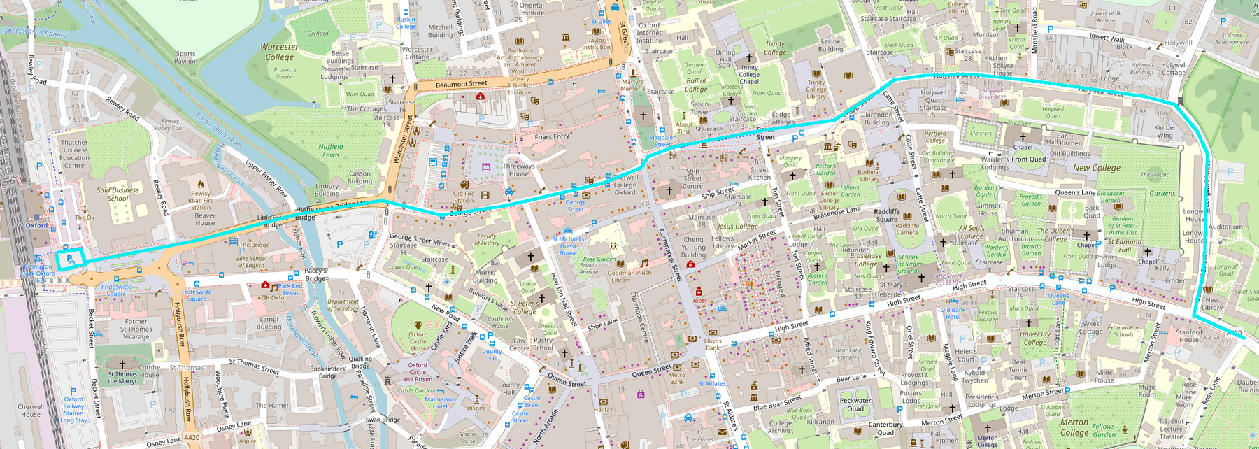
This outlines a plan for a direct, coherent east-west foot-cycle route across Oxford's city centre. That would run from the railway station across the north of Frideswide Square, along Hythe Bridge St, George St, Broad St, Holywell St, and Longwall St, ending at Magdalen Bridge.
There is currently no safe and accessible cycling route across the city, and the walking options are almost as dismal, with Hythe Bridge a particularly horrible section — try getting from the railway station into the centre with a large suitcase, pushing a buggy, or in a wheelchair. If the county is serious about both the ambitious cycling targets in the Local Transport and Connectivity Plan and its commitment to "decide and provide" planning, then it needs to work backwards from this kind of problem and take a broad perspective, otherwise individual schemes will not cohere to create coherent routes. We need the City Centre Movement Framework promised in the Central Oxfordshire Travel Plan.
As well as providing east-west connectivity across the city, this scheme would create a focal axis for the city that would help to make the northern side of the city centre more attractive and rebalance footfall away from the Westgate shopping centre. (I'm wary of grand designs that put form before function, but this could be implemented with uniform design features, to make it a "feature". From the railway station to Longwall Street is right on one mile, so this could be branded as "the Oxford Mile", as suggested by someone in a tweet I can no longer find.)
Once the space required for movement (walking, cycling, essential motor vehicles) is allocated, there will be competing demands for the remaining space, with seating, greenery and sustainable drainage, cafe tables, and cycle parking being the obvious ones.
Frideswide Square
Cycling is allowed anywhere here, with the result that it is poorly provided for. In particular, there is no coherent provision for moving between the carriageway and the footways and no guidance to separate people walking and cycling. And the lack of any pedestrian priority crossings fails slower, less confident, and disabled pedestrians.
A two-way cycle track would be marked on the northern side of the square, with priority over the station entry road and in line with and connecting directly to Hythe Bridge St. At its western end, the cycle track could be anchored in an upgraded cycle parking facility. Parallel crossings would be put in to help both pedestrians and people cycling cross the motor traffic flows south of this track.
Hythe Bridge
This is the major bottleneck, with just 9.5 metres between the bridge parapets. That allows for two 2.75m footways on either side of a 4 metre two-way cycle track. The latter would be usable by emergency vehicles (access would be controlled by ANPR and/or a rising bollard), but all other traffic filter-exempted motor traffic would be routed via Park End St (exemptions might need to be adjusted to ensure there is no congestion there). The traffic filter would be shifted to Worcester St North.
Hythe Bridge St
This would carry no through motor traffic other than emergency vehicles, providing motor vehicle access (from Frideswide Square) only for emergency services, shop loading and services, and the residents on Upper Fisher Row. It would be a "cycle high street", prioritising foot and cycle traffic and space for people - a four metre wide cycle track would allow wide footways with room for cafe seating, etc. as well as time-restricted loading bays. This has the potential to be a really nice space.
the Worcester St junction
If the bus station can be relocated, this junction would be fairly simple, with buses and exempt private motor traffic going north-south along Worcester St crossing the main east-west foot-cycle flows, and only access/service motor traffic turning into George St.
George St
George St would be a pedestrian space with a 4 metre wide cycle track down the middle, usable at loading times by service/etc motor vehicles (one-way, linked to Magdalen West). This would be another "cycle high street" - some space might be available for cycle parking or cafe seating, but providing adequate space for people to stand around or walk comfortably would take precedence over that.
Cornmarket and the Magdalen Sts
Space constraints and extremely high pedestrian flows make this junction unsuitable for the bus traffic it currently carries. Buses would be relocated to Beaumont St and/or St Giles, allowing this entire area to be pedestrianised, with the east-west cycle track continuing across from George St into Broad St. There would also be two-way cycle tracks on Magdalen Sts East and West, with the latter used by one-way loading/service motor vehicles, in conjunction with George St.
This presupposes relocation of local buses from George St and Magdalen Streets East and West to Beaumont St and St Giles. This would require reconstruction of St Giles as a kind of bus hub, perhaps with a cycle-taxi shuttle service to transfer people with limited mobility between that and the buses on High St and St Aldates.
Broad St
There is still too much motor traffic here, and the layout is still fundamentally that of a road. It should be a pedestrianised public space with cycle tracks through it, with the latter also supporting essential motor traffic.
The few buses currently using Broad St could perhaps use Holywell/Mansfield or Radcliffe Square to turn, or they could use the space one-way, exiting or entering from the west, in a similar way to the buses currently using Queen St - at 5mph and giving priority to people walking and cycling.
Holywell St
People already walk on the carriageway here, making it effectively shared space. It could either be made properly shared space (like Pembroke St) or reconfigured with wide footways and a central cycle track usable by motor traffic to New College or delivering to the few shops.
Longwall St
Providing adequately for walking and cycling here requires motor traffic to be restricted to emergency services and local buses only, with a proper bus gate rather than an exempted traffic filter. Buses would move slowly (as on Queen St) and with just 12 buses an hour in peak, communications might allow south/east-bound buses to wait when a north/west-bound bus is coming, preventing the narrowest section having to support two-way motor traffic (allowing 2 metre footways on either side of a 4 metre cycle track/bus lane).
Make it so! This is a very common path for both residents and tourists but makes an absolutely dismal welcome to Oxford at present.
Perhaps we could finally make Gloucester Green … green again as a public park?
Note that this would follow close to the path of the old city defences for much of its length: one could play on that medieval geography and the endpoints with a name such as Frideswide’s Wall?
Great idea but why not take the route down Queens Lane thereby avoiding Longwall Street?
Queens Lane is unsuitable for large volumes of cycle traffic - that would exacerbate existing conflicts with pedestrians.
I am a frequent visitor and applaud this initiative. As a segregationist I would ask what route would you plan if the TdF was going from McDonalds on Botley Rd to beyond the Plain and also if later 5 year-olds (unsupervised) were taking the same route for a week. You would be allowed to ban any cars, buses, pedestrians you wanted and you had a budget of say £100M to make the route safe, continuous, and non-stop. Personally I like cycling down High St until I get near to Carfax - then it is buses, buses, buses.
Even the Dutch don't plan for unaccompanied five year olds cycling any significant trips! (Maybe around the local woonerf.) But five year olds cycling alongside adults is more plausible, and it is interesting looking at the bottlenecks to 8-80 cycling on a route from Botley to East Oxford. The route I describe could be laid out to support inclusive cycling (the big/hard changes would be relocating the bus station and putting a bus gate on Longwall), but that leaves Botley Rd to the west and the Plain to the east.
One of the worst bottlenecks here, the railway bridge, is in the process of being rebuilt with 4 metres for walking and cycling in each direction. The Thames Bridge would need a new pedestrian bridge on one side, leaving 11m for a 5.5m central carriageway, 2m for the other footway, and 3.5m for the two cycle tracks. With some of the narrow stretches of road the best we can do (barring some serious compulsory property acquisition) is probably an Iffley Rd style Quickways treatment. If we can get enforced 20mph speed limits and a general reduction in motor traffic I think that's actually close to 8-80 accessible.
At the other end, there are a lot of ideas about the Plain...