
What is the road layout on Oxford's Iffley Rd and how is it supposed to work? The key features here are the use of advisory cycle lanes around a narrow central traffic lane with no centre line; between Donnington Bridge Rd and the Plain the cycle lanes are mostly 1.575m wide and the central lane ranges from 4.66m to 5.93m wide. (This was implemented on Iffley Rd as part of the "Quickways" schemes in 2022. A similar scheme was implemented on Magdalen Bridge in 2020; there the cycle lanes are 2m wide and the central lane is 5m.)
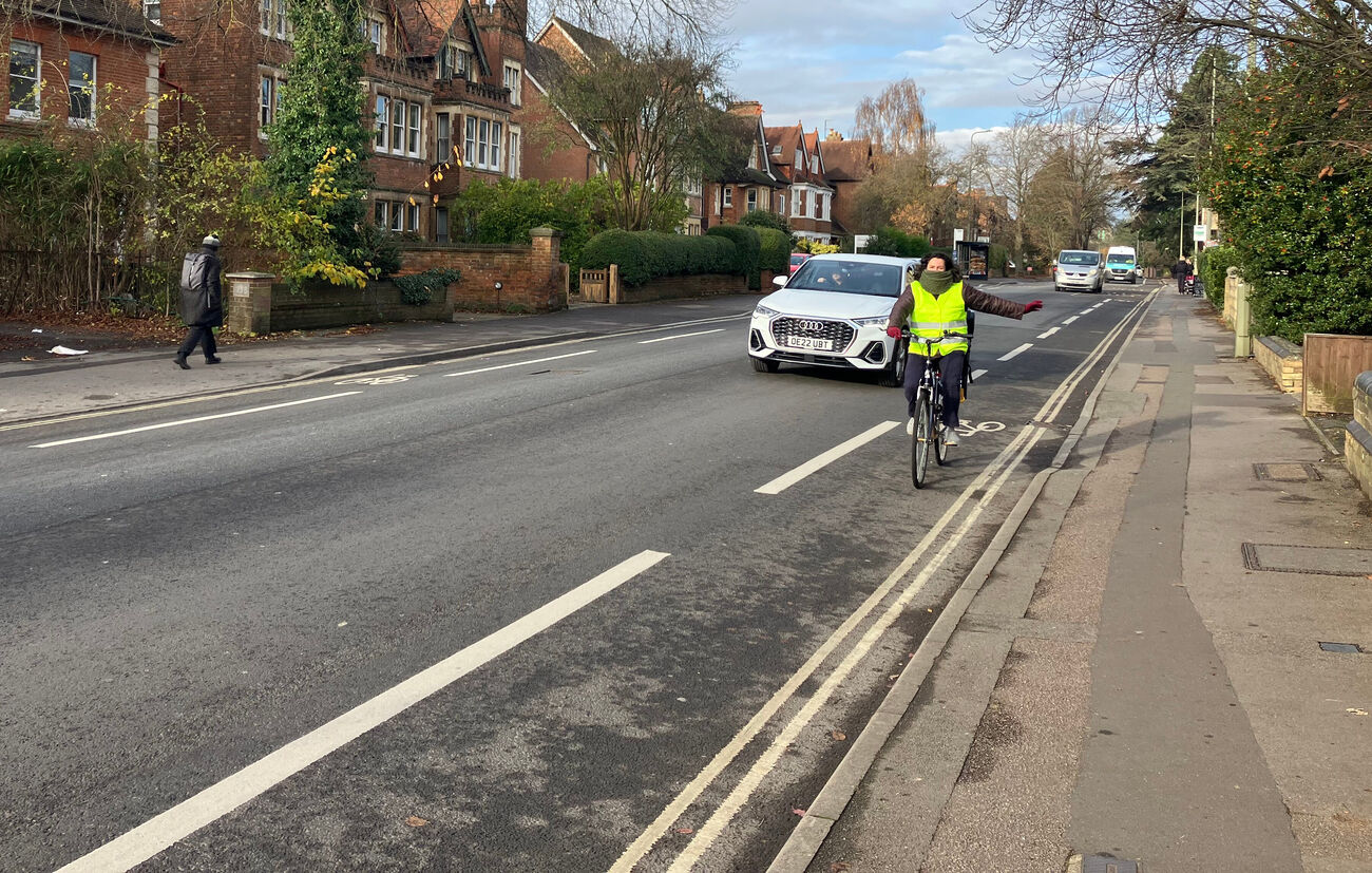
The stretch from Marston Rd to the Plain was already 20mph, but the remainder of Iffley Rd was changed to 20mph as part of the Quickway schemes. Those also involved removing the remaining parking, allowing the cycle lanes to be continuous. Which complicates evaluating the effects of the Quickways.
Elsewhere
[This is a bit technical: feel free to skip to "Evaluation"]
The term "Quickways" is Oxford-specific and not used anywhere else, and there is no name for this layout in Britain. In the United States they are called "Edge Lane Roads", in the Netherlands suggestiestrook, in Denmark "2-minus-1 roads", in France chaucidou, and in Switzerland (some cantons) Kernfahrbahn.
There are different guidelines for rural areas - with higher speeds - and debates over the appropriateness of this layout there at all. Here I just consider recommendations for use in urban/built-up areas.
- In Denmark, "2-minus-1 roads" are used with speeds <50km/hr and low levels of traffic (<300mv/hr or <3000 ADT), and typically have a 3-3.5m centre lane and 0.9-1.5m edge lanes.
- In the Netherlands, "suggestiestrook" are used only at 30km/hr, with traffic levels >2000 ADT but < 5000 ADT. The cycle lanes are supposed to be 1.7m minimum width and are coloured. They have no legal status and are deprecated, but in Utrecht these have been put in in a few cases to replace separate cycle tracks, on streets where very high numbers of people cycling will dominate motor traffic.
Suggestiestrook are not to be confused with a "fietsstraat", which is a shared space treatment used in residential access roads: also 30km/hr, but <500 cars/day and 2x as many bikes as cars.
- The Swiss guidance is for use only in built-up areas, with "a cycle lane width of at least 1.5 meters and a centre width of at least 4.5 meters for the centre lanes".
- In the United States, the Federal Highways Administration insists on <6000 ADT, preferably <3000, with speeds <35mph (recommended <25mph), edge lane >4ft / 1.2m (with no kerb or gutter, recommended 6ft / 1.8m), and central lane 4.2-4.9 metres (potentially 3-5.5m)
Iffley Rd currently carries about 10,000 motor vehicles and 3,000 cycles/day, at its northern end.
Evaluation
The changes are clearly an improvement for cycling on the previous situation. Anecdotally, almost everyone I've talked to finds it better - and some people are now willing to cycle along Iffley Rd where they weren't previously. The county's counts appear to show an increase in cycling but are hard to interpret.
Compliance with the speed limit is not great, but speeds have dramatically decreased - typical speeds are now around 23mph, with hardly anyone going over 30mph. Traffic flows seems steadier, with less stopping and starting (the parking removal will have helped here), and actual throughput is (for most of the day) limited by queues at the Plain or the DBR junction, so this is more economical, less polluting, and quieter.
Compliance with the cycle lanes is also remarkably good. Cars can mostly pass each other within the narrow central lane, and while buses and larger vehicles need to encroach on cycle lanes to pass there aren't too many of those. And a majority of drivers are prepared to delay overtaking people cycling. It would be good to have measurements of passing distances (instrumentation exists for this).
Cycling along Iffley Rd is, of course, not the major problem. But making cycling right-turns onto or off Iffley Rd is also easier. Sometimes the smoother traffic flows seem to lead to longer waits for a gap, but the slower traffic makes it easier - and safer - to make those turns. And there are big gains for pedestrians: drivers are more likely to stop at zebra crossings when going slowly and informal crossings are much easier with the lower speeds. The removal of the parking has also improved visibility, for both cycling turns and pedestrian crossings.
There is a kind of positive feedback loop between speed, behaviour, and mode choice here.
To my mind, this layout works best for cycling with:
- lower speeds - safer and less stressful for people cycling when being passed, and car drivers at lower speeds are more likely to delay passes and will tolerate closer distances to oncoming motor vehicles;
- more people cycling - this will tend to keep car drivers from encroaching into the cycle lanes;
- lower volumes of motor traffic, especially of buses and HGVs; and
- clear distinction of the cycle lanes.
This means that the effectiveness of the Iffley Rd layout is likely to improve with coming changes.
- Deployment of average speed cameras or other police enforcement, ubiquitous 20mph speed limits in built-up areas (being rolled out across the county), and increasing numbers of cars with Intelligent Speed Assistance would all improve compliance with the 20mph speed limit.
- The county has a target of greatly increasing cycling rates, and there are exogenous measures that would greatly increase cycling rates on Iffley Rd, most obviously making the Plain safer and more accessible.
- The traffic filters will significantly reduce the amount of motor traffic on Iffley Rd, and less congestion should allow bus provision to be improved without an increase in bus numbers. Enforcement of the 7.5 tonne limit on Longwall St would remove some of the HGVs.
- Colouring cycle lanes is not county policy, but would improve compliance with the marked lanes (legibility could also get worse - with this layout, it will be important to keep the cycle lane markings refreshed when they start to wear).
Alternatives
The Iffley Rd layout may be better than it was before, but is it possible there are even better alternatives? The most obvious call is for better separation from motor traffic, either with more wands or with kerbs. Alternative approaches to cycling provision can be seen on the Slade (half-height "Cambridge kerb" cycle tracks) and on Botley Rd and Headley Way (on-footway cycle "tracks").
One key constraint is that, if motor traffic is to be restricted from entering the space allocated for cycling, that means giving it more room. The bus companies want 6.4m for two-way bus operation but will accept 6.2m if necessary. That means that for Iffley Rd (north of Donnington Bridge Rd), something like 1.2m would need to be reallocated from the footways to the carriageway. And maybe another 0.3m to the cycle tracks, to bring them up to 1.7m width.
So the first problem is that this involves shafting pedestrians: instead of 3m and 2.5m wide footways they might have 2m wide ones. Given the very high pedestrian flows on Iffley Rd, especially towards the Plain, and the existence of the usual plethora of intrusions onto the footway, that isn't adequate.
The other problem is that it's not clear that this would help people cycling much:
- It wouldn't provide a spatial buffer from motor traffic. And with a clear 6.2m, unconstrained by having to think so much about people cycling, that motor traffic is likely to be going faster.
- A 1.7m wide cycle track does not provide enough width for comfortably overtaking, especially if wider cycles or wands are involved - and either wands or kerbs would complicate using the carriageway to overtake.
- The narrower footways would result in people walking much closer to the cycle track, or even walking in it in order to pass other pedestrians.
- Wider traffic lanes would make crossings worse for pedestrians, and kerbs or wands would complicate cycling right-turns onto Iffley Rd. The cycle tracks would probably (if the Slade is a guideline) change colour and/or height across side entries, making them less clearly continuous than the current cycle lanes.
(I've also seen suggestions that a cycle track be provided in one direction along Iffley Rd, with no infrastructure at all for cycling the other way. Since most trips are there-and-back, this seems unlikely to work at all well: it doesn't matter how good half the trip is if the other half requires cycling with motor traffic and no separate space at all.)
But I think we can go even further with this argument. Imagine we were given, by magic, an extra metre and a half of width on Iffley Rd. Would it be better to give it to motor traffic, allowing the cycle lanes to be replaced with kerbed cycle tracks similar to those on the Slade? Or would it be better to give it to the cycle lanes, allowing them to be widened to 2m like the ones on Magdalen Bridge? My suspicion is that, given the high numbers of people cycling along Iffley Rd - which are intended to increase - the latter would actually be more useful.
The Actual Problem
To some extent this is a nugatory debate. The real problem now is not what kind of cycling provision there is along Iffley Rd, but addressing the junctions at either end of it. The Donnington Bridge Rd junction provides no support for anyone cycling trying to turn right onto Donnington Bridge Rd or Boundary Brook - and still gives simultaneous green lights to people cycling north and motor traffic turning left into Donnington Bridge Rd across them. And the problems with the Plain need no elaboration.