This was a response to a consultation on the Greenways. Please let me know of any errors or omissions.
Planning Coherence
Having the university and city council as partners in the Greenways project is valuable, but there are downsides to yet another management body and accompanying siloisation. Ultimately decisions about the Greenways schemes have to be made by a county body which also manages the Strategic Active Travel Network, new or upgraded walking and cycling infrastructure accompanying highways schemes and developments, and upgrades to bridleways and other public rights of way. Otherwise we risk disconnected planning of the Oxfordshire-wide cycling network. It is also odd to have Oxford city council more closely involved than the district councils through which most of the Greenway routes will run.
This awkward management structure is already creating some confusion. A large fraction of the concerns and queries I have seen about the Greenways project relate to its omission of key routes - especially along the B4044, A4074, and A40 - which are already being evaluated as part of other projects. These are mentioned in the Greenways background materials, but many people don't look past the map. There needs to be a single web page, with a map, showing all the planned routes around the county and their current status. Members of the public should not be expected to understand the difference between a Greenway and a non-Greenway route, let alone the complex structure of county workstreams or the arcane mix of active travel funding sources.
Ring-Road Severance
The covering material says "the geographical scope for the project has been defined as the area that can be covered by cycle routes of up to 10 km from the Oxford Ring Road outwards". Having routes stop just outside the ring road and ignoring connectivity across that will leave some routes unusable by many people, or of limited use. In some cases, consideration of ring-road severance issues would suggest alternative routing.
A core strength of the Greenway approach is in providing complete, coherent routes, connecting up bits and pieces of infrastructure put in as part of highways schemes, housing developments, and so forth. Failing to address ring-road severance and to bring the routes all the way into central Oxford undermines this.
Wayfinding
The distinctiveness of the branding is not that important. Perhaps some Oxford residents will try to cycle or walk all the Greenways, as some kind of personal achievement, but otherwise no one will care whether they are on a Greenway or on some other kind of route. It is important that routes are clear and distinct from one another, that cycle routes aren't confused with walking only routes, and that any significant accessibility issues are marked.
Wayfinding should be coordinated at a county-wide (Strategic Active Travel Network) level, not at a Greenways level. People cycling around Oxfordshire want a consistent waymarking scheme, not one for (say) their route from Oxford to Eynsham and another for their route from Eynsham to Long Hanborough. And keeping at least some design elements consistent nationally would be helpful.
Several of the routes have sections that "may not be suitable for all users". Any waymarking system (and mapping) needs to distinguish between genuinely inclusive routes — accessible to anyone who can walk, wheel or cycle — and routes which might lack footways, or involve cycling on roads with motor traffic in significant volume or moving at speed. If routes are unusable by larger cycles that needs to be marked.
And the wayfinding needs to run right into the centre of Oxford. Even if the Greenways routes officially stop at the edge of the city, people using them will need guidance to continue towards the city centre (which is in many cases going to be more complicated navigationally) or, coming out of the city centre, to reach them. This may be less of a problem for commuters, who can spend some time finding the best route and will have employers or colleagues to advise them, but is vitally important for recreational use. Someone arriving by train, intending to cycle to one of the villages around Oxford, really wants to be able to pick up a Greenway route somewhere near the city centre, or at least a single, clearly marked internal route that will take them to the start of the appropriate Greenway route. Even if the cycling provision on Woodstock Rd isn't part of the Woodstock Greenway, for example, it should have signs showing that it connects to that.

Prioritisation
It would be good to have a costing, however rough, for all the proposed routes, along with a rough outline of possible funding sources. Without that it is hard to do any kind of prioritisation. Discretionary funding, provided by the councils themselves, could perhaps target the routes that will be most heavily used, but there might be an argument for it going to the routes where other funding (from housing developments, or perhaps from Active Travel England) will be hard to come by.
Design Details
For the Greenways to be accessible - to people walking or cycling with children, less confident adults, and so forth, getting the design details right is essential. This is also key to making the routes genuinely attractive "Greenways" and not just generic cycling routes.
Cycling on carriageway, mixed with motor traffic, should only be part of the routes where motor traffic volumes are low (<1000mv/day) and traffic speeds are, or can be reduced to, around 20mph. Stretches with up to 2500mv/day are acceptable (following the LTN 1/20 guidance), but increasing levels of motor traffic will significantly detract from any "green" feeling and a car every 15 seconds (2500mv/day at peak times) is a much bigger deterrent to cycling long distances on a rural road than to cycling shorter distances in an urban setting. If there are no footways and people are expected to walk on a carriageway shared with motor traffic, it is even more important to keep traffic volumes and speeds low. Where putting in adequate traffic calming would be too expensive or intrusive, and off-road paths are impractical or too expensive, modal filtering should be considered.
Where people are walking or cycling on a path alongside a road with either >20mph speeds or significant numbers of HGVs, all efforts must be made to provide a buffer of some kind between the path and the carriageway, and the larger the buffer the better: 30cm is better than nothing, and 80cm is better than 50cm. There is a huge difference, both psychological and practical, between having only an ordinary kerb separating one from motor traffic, and having raised kerbing or another kind of barrier which might catch one if one slips or slides. The LTN 1/20 ("Cycle Infrastructure Design") minimums for buffers (e.g. 0.5m with 30mph traffic) should not be used as targets, but improved on wherever possible, and the "absolute minimums" for buffers (e.g. no buffer with 30mph traffic) should only be acceptable where there are unresolvable physical space constraints.
In several of the route appraisals there are statements like "consider carriageway narrowing". Carriageway narrowing should be considered everywhere it is possible; as well as providing space for extra path width or buffering, it will also help to keep motor traffic speeds down. Space can be fairly easily reallocated by relining the carriageway and putting a buffer of some kind down its edge; it does not necessarily need a full carriageway rebuild.
And of course the crossings and junctions need to be safe and accessible.
For the Greenway routes to be attractive for commuting and faster recreational cycling, it is important that they support expeditious movement. The general design should support at least 15mph and preferably 20mph cycling speeds and any signal crossings need to be low latency (sub 20 second wait) and single stage (at least for cycling).
1 - Woodstock
It is hard to see this feeling at all like a "Greenway", given it is almost all alongside busy A roads. However it is an important route which could carry large volumes of cycling, with some shorter segments being heavily used by pedestrians. Several sections of this route have been recently improved, but a lot of it needs upgrading to be safe and accessible, and a "whole route" treatment will provide coherence and continuity.
The most important design elements here will be making the along-road paths as comfortable and attractive as possible, with buffering from the carriageway, and making sure the crossings involved are safe and accessible — and feel safe.
The proposed route just gives up completely at the Wolvercote roundabout. That is no less important than any of the other crossings and junctions on the route and is currently extremely hostile. If walking and cycling across this roundabout can not be significantly improved, then this route should either be rerouted along the canal path, like National Cycle Route 5, or to the Cutteslowe foot-cycle bridge.
2 - Otmoor
Sheperds Pit will need filtering to be an accessible walking and cycling route. Any attempt to keep speeds to 20mph will either (most likely) fail or create an effective modal filter by making the alternative route via the B4027 and Bayswater Rd faster. It would be both cheaper and more effective to put in a modal filter, leaving very occasional farm access traffic.
There are already plans for a two-way cycle track along the west side of Bayswater Rd, south of Bayswater Brook, and upgrades to the underpass approaches, as part of the Land North of Bayswater Brook development. There may be room for other synergies, so planning for this route should be coordinated with that development.
Again, the proposed route stops just outside the ring-road, where connectivity is provided by a narrow subway which is unusable by larger cycles.
3 - Boars Hill
Modal filtering of Oxford Rd seems implausible and putting in separated infrastructure extremely challenging, but the proposed alternative routes are quite roundabout unless it is possible to go through Bagley Wood. If that is possible, then there may be other options as well as the one marked, so the landowner should be consulted before any further work is done on this route.
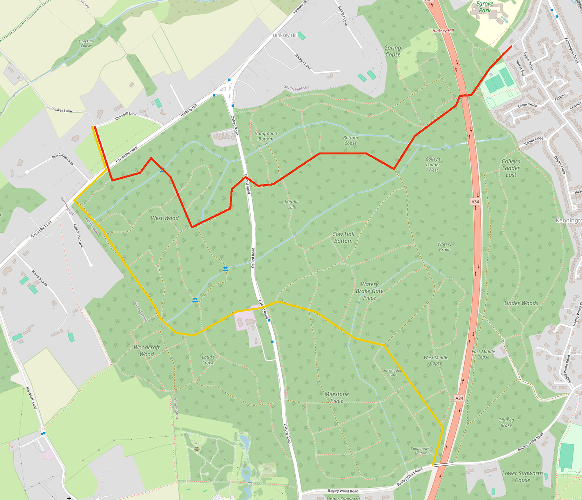
A route coming along Bagley Wood Rd provides good access to Kennington, but consideration needs to be given to connectivity through Kennington both southwards to Sandford Lane (and Radley/Abingdon) and northwards towards Oxford. (A route along Sugworth Lane would connect nicely both to Sandford Lane and NCN 5 towards Oxford and to the cycle paths towards Abingdon, and consideration should be given to filtering Sugworth Lane regardless of the Greenways routing.)
4 - Wootton + 5 - Kingson Bagpuize
Westminster Way is quite hostile for cycling, so there needs to be some plan for the final stretch of these routes to reach the A34 underpass.
6 - Wytham
Much of this route is currently National Speed Limit (60mph). While few people will be driving at that speed, significant infrastructure is going to be necessary to get speeds down to around 20mph so that cycling on the carriageway is and feels safe and comfortable.
Much of this route lacks any footway at all, which makes it problematic as a pleasant walking route given the non-trivial amount of motor traffic. Modal filtering is probably the only way to make the route south of Wytham into any kind of "green" walking route. The highest priority is probably providing footways on the stretches of road between Wytham and Lower Wolvercote (about 500 metres in total) which currently lack them.
Stopping the route at the A34 is completely arbitrary and makes no sense at all, as it leaves the route ending in the middle of nowhere. It should be continued at least as far as Lower Wolvercote (which has a bus service).
Other Routes
Other key routes include those along the A40, both east to Wheatley and west to Eynsham and Witney, to Berinsfield along both the A4074 and the Roman Road bridleway, and along the B4044 to Eynsham.
Wolvercote roundabout appears on the draft COMPF map with the following possibilities:
- Improvement of crossings for pedestrians and cyclists on all five arms of the roundabout
- Potential review of traffic lights phasing to facilitate ped/cycle crossings
- Re-design of some of the arms to improve crossings (Five Mile Drive, Godstow Rd)
I'd actually missed that - haven't got through all the COMPF schemes yet! There's also some money from Oxford North for improvements to the Wolvercote roundabout (and some from the PR6A development for improvements to the Cutteslowe roundabout). They're both really challenging: extreme space constraints at Cutteslowe and six arms at Wolvercote.