One way to see how little consideration walking and cycling are given in Oxford is to look at the main road junctions. So stealthily and incrementally, over decades, have time and space at these been reallocated to motor traffic, at the expense of other modes, that people have become habituated to it and are mostly oblivious to how bad they are. We need all of Oxford's junctions rebuilt to prioritise walking and cycling safety and accessibility over motor traffic throughput.
The three examples I use here are chosen because I know them, but a similar analysis would hold for most of the major junctions in Oxford.
Iffley Road - Donnington Bridge Road - Boundary Brook
This is a signalised junction where Donnington Bridge Rd (the B4495) meets Iffley Rd (the A4158); it looks like a T-junction, but is actually a crossroads with Boundary Brook as the offset fourth arm. These roads are 30mph, though Boundary Brook becomes 20mph almost immediately. This junction is prioritised for motor traffic, with pedestrians given the minimum possible consideration and pretty much no provision for cycling at all.
First of all, consider crossing it on foot. Donnington Bridge and Iffley South have two-stage (caged) signalled pedestrian crossings, but there is no provision for pedestrians at all on Iffley north (there is a signalled crossing 130m to the north, near Fairacres Rd) and Boundary Brook has a bricked pseudo-crossing. In the worst case, anyone trying to get from the north side of Donnington Bridge Rd to the southeast of Iffley Rd faces four signalled stages — or a 250 metre detour via the crossing to the north — followed by an unsignalled crossing of Boundary Brook. This can take over four minutes in peak hour, and three minutes is quite common. And crossing Boundary Brook at the junction is highly unpleasant, because it has widely flared corners and traffic entering at speed.
It is true that most pedestrians don't wait for the green man and jump the lights on some or all of the stages, but a junction design that has that happening regularly is clearly not working properly. This is also a risky model for children, who are poor at judging vehicle speeds and harder for drivers to see. (Even waiting for a green man provides no certainty: some drivers, especially on left-turns, ignore the red lights if they can't see anyone waiting to cross and go through them without slowing much, which is possible because the junction is so spacious.)
Cycling is even worse provided for than walking. There is almost no provision for turning right — there are "bicycle boxes" on all the approaches, but those are only useful when the traffic is stopped. Motor traffic tends to be either congested and slow-moving, requiring cycling movements between vehicles, or moving at speed, requiring crossing one lane of traffic and merging with another. Going straight on is easier, but still involves crossing motor vehicles turning left, risking left-hooks. The cycle lanes disappear completely inside the junction and it is quite common when cycling to be overtaken (or undertaken) inside the junction, especially as the junction is over 25 metres wide from north to south.
Turning left is safer — and those turning left may be able to avoid the junction entirely, using Addison Cr or Freelands Rd. (Trying to do this when turning right requires unprotected right-turns off and then onto main roads.) The alternatives to this junction can involve fairly long detours, with Meadow Lane 450 metres to the west and Cricket Rd 700 metres to the east (the lane connecting Boundary Brook to Howard St is not suitable for volumes of cycle traffic, and only usable in one direction because Howard St is one way).
This junction (and the volumes of traffic on the roads it connects) is a massive contributor to community severance. It stops parents letting older children walk to nearby primary schools and deters slower or frailer adults from walking to the Donnington Medical centre or the Coop store. It prevents parents cycling to the schools with their children, and deters adults from commuting by cycle and children from cycling to secondary schools. Which feeds into further health problems due to physical inactivity — and creates more motor traffic, when children are driven to school instead, care workers have to transport people for medical checkups, and people drive instead of using local shops.
Iffley Rd is an A-road, so the county's transport strategy allows it to prioritise motor traffic there. However the county is not obliged to do this, and that it has chosen to optimise for motor traffic throughput at the expense of walking and cycling makes its priorities clear.
It is also clear that the progression here has been towards getting more cars through here, faster, at the expense of everything else. This can be seen in our next example.
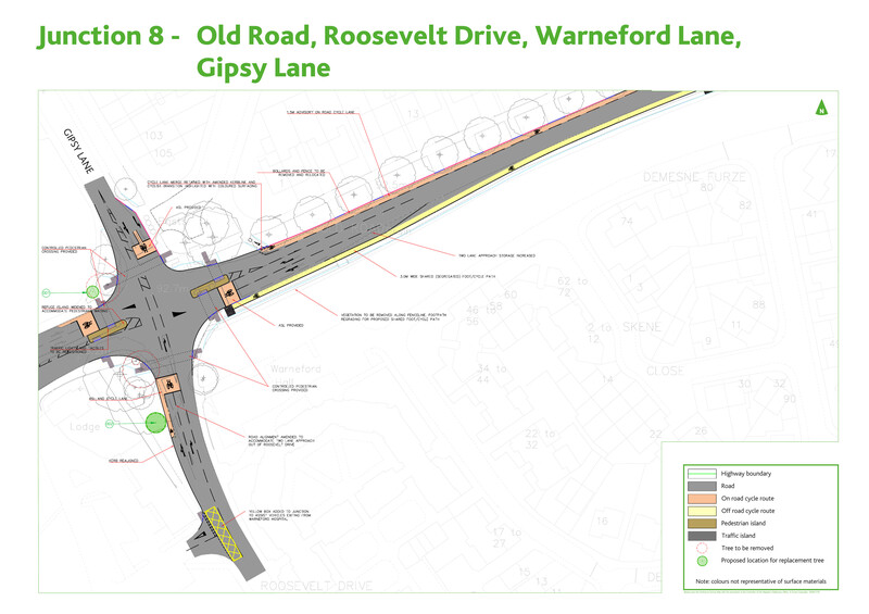
Warneford Lane - Gypsy Lane - Old Road - Roosevelt Drive
This is a cross-roads, technically of unclassified 20mph roads. It feeds through routes via Morrell Avenue or Divinity Rd as well as supporting access to local sites, so it carries large volumes of traffic, especially in peak hour. Cheney High School sits on one corner and the Warneford Hospital on another; back a bit further lie the main campus of Brookes Uni, the Old Rd campus of Oxford Uni, and the Churchill Hospital.
This junction was rebuilt in 2016-2017, so we can see the direction of change. The rebuild added a right-hand turn lane on the only approach that had lacked one ("road alignment amended to accommodate two lane approach out of Roosevelt Drive") and the right-hand turn lane on Old Rd was increased in length ("two lane approach storage increased"). This made things worse for other modes: all cycling right-turns now involve two lanes of motor traffic, all the pedestrian crossings are of three lanes of motor traffic (in two stages with Old Rd and Warneford Lane), and the westbound cycle lane on Old Rd does a jump onto and then off the pavement.
For walking this is marginally better than Iffley-Donnington: it has signalled crossings on all entries, and no movements require more than three signal phases. But a diagonal movement can still take nearly three minutes.
The problems here for cycling are pretty much the same as at the Iffley-Donnington junction discussed above: anyone heading straight on risks being left-hooked, turning right either requires getting into the "bike boxes" before the lights change or crossing one lane of traffic and merging into another, and so forth. Overall this junction is not as bad, however, largely because it is more compact, the speed limit is 20mph, and it carries lower volumes of traffic.
The cycle "lane" on Warneford Lane is notoriously dangerous, but in any event simply disappears at the junction, while the "on footpath" cycle lane on Old Rd does an abrupt rightwards jump to get back onto the carriageway, which is really dangerous in moving traffic. There is no provision at all for people cycling to connect to Grays Rd, which provides a low-traffic route towards Headington and the John Radcliffe hospital, but people use this route anyway, leading to potentially unexpected cycle movements off Old Rd to Grays Rd and from Grays Rd onto Gipsy Lane.
Warneford Lane is the major cycling route connecting East Oxford with Headington, with the alternatives being to go around the bottom of South Park a kilometre to the west (and face the awful cycle up Headington Rd) or to use the Hollow Way 1.5 kilometres to the south east, since the Warneford Meadow route is unusable in winter or wet weather and doesn't connect to anything coherent at its northern end. (There are only informal south-north routes to the east of the junction, with no or poor connections across Old Rd, from Demesne Furze to Valentia Rd or from the university campus to Stapleton Rd.) So this junction, along with the failure of provision on its approach roads, is the major deterrent to a huge range of potential cycle trips. The junction is largely unloaded outside peak hour, but the features designed to improve motor traffic throughput in peak discourage people walking or cycling all day long.
Cheney school urges its students to walk or cycle to school, but a junction like this massively inhibits that — especially cycling, which should be the modal mode for a secondary school with a reasonably large catchment. Parking is a notorious problem at the Churchill Hospital and getting even 5% of currently driven trips shifted to cycling would significantly alleviate that.
The Plain Roundabout
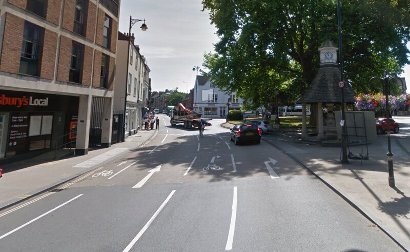
Connecting three major arterials — Iffley Rd, Cowley Rd, and St Clements/London Place/Headington Rd — to Magdalen Bridge/High St, along with Cowley Place as a minor fifth entry, the Plain roundabout is one of the busiest junctions inside Oxford. It is a key bottleneck in access from (or through) East Oxford to the city centre, with the nearest alternative routes being Donnington Bridge to the south and to the north a foot/cycle track from Marston over Peasmoor (that floods).
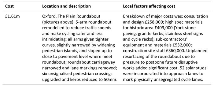
The Plain was rebuilt in 2016, using "Cycling City Ambition" funding and with the goal of making cycling better. To see how poorly that worked, there were 28 cycling casualties in 2013-2015 and 33 in 2017-2019 (Bikedata) and for a while in 2018 the county felt obliged to put up bright yellow "Think Bike" signs to try to get drivers to take extra care. And, as elsewhere, the crash record here is only the tip of the iceberg. The bigger problem is that this roundabout is so hostile that it deters the less confident and vulnerable from cycling at all.
The Plain is, along with the junction at Longwall on the other side of Magdalen Bridge, the major obstacle to cycling from (or through) East Oxford into the city centre. It is probably the leading reason more than half the population of East Oxford won't ever cycle into town.
This routine took me some time (and a few near-accidents) to work out, so isn't going to be obvious to new or infrequent cyclists. It also relies on my confidence to hold a lane against sometimes impatient drivers, to be able to move at some speed, and to carry out rapid evaluation of different risks. I understand that this simply isn't an option for many people — and I wouldn't contemplate doing this while cycling with my seven year old.
The Plain isn't as bad for walking, but getting around it can still be nerve-wracking. There are informal buff-coloured "crossings" but no signals or zebra crossings, and walking across the arms requires making decisions about traffic speeds, possibly of motor vehicles and cycles approaching simultaneously — and crossing the entry from Magdalen Bridge involves getting across two cycle lanes and two lanes of motor traffic with no protection. There are pedestrian islands, but most of them are too small for the number of people using them, especially if wheelchairs or buggies are involved. And the high density of buses adds to the difficulties, with people cycling alongside them unable to see (or be seen by) either approaching traffic or crossing pedestrians.
Solutions
There are small tweaks that could be made to improve these junctions: the cycle lanes could be continued across junctions and coloured, parking could be removed on the approaches, the speed limit at the 30mph Iffley-Donnington junction could be lowered to 20mph, and so forth. But after decades of optimisation for motor traffic, there's no way to seriously improve things for walking or cycling without accepting some adverse effects for motor traffic. To prevent them inhibiting walking and cycling, these junctions need to be redesigned for lower peak volumes of motor traffic.
Lower levels of traffic would immediately and directly improve unsignalled pedestrian crossings and many cycle movements, but more importantly would allow changes to the junction designs. Signal timings could be changed to make all the crossings single-stage, and to include separate cycle phases, and to use 1m/s instead of 1.2m/s as a walking speed. The separate right-hand turn lanes could be removed, shortening crossing distances for pedestrians and creating space for separate cycle lanes and cycle waiting areas. And smaller and "tighter" junctions would naturally slow motor traffic. It might be possible to use some kind of "simultaneous green", allowing all pedestrian and cycle movements at the same time.
Alternatively, some of these junctions could be candidates for a Dutch-style roundabout with a protected peripheral cycle track (versions of which have now been built in Cambridge and Manchester). At the Plain, proposals along those lines were scotched in 2016 by the bus companies, which insisted on a two-lane entry off Magdalen Bridge to avoid congestion, but if non-bus motor traffic were drastically reduced (say by a bus gate on St Cross Rd) then this would not be such a problem. The Dutch CROW manual suggests a single-lane roundabout is feasible for junctions with up to 1500 "passenger car units" (weighted for trucks and buses) per hour in peak on the busiest arm, which would be consistent with the roughly 200 buses (600pcu) and maybe 1000 cycles (500pcu) per hour that Magdalen Bridge carries in peak. Space is a problem for these designs, but there appears to be some to spare to the southwest of the Iffley-Donnington junction and to the northeast of the Old-Warneford junction.
Lower traffic volumes could be achieved using congestion or access charging, using bus gates or other restrictions, and by reducing parking. A bus gate on Warneford Lane would significantly reduce motor traffic volumes at the Old-Warneford junction, and a Workplace Parking Levy would shift some commuters to the universities, hospitals and schools away from driving. A bus gate at St Cross Rd (or on Magdalen Bridge) would decrease motor traffic at the Iffley-Donnington junction as well as at the Plain. A School Streets scheme on Boundary Brook (for Larkrise Primary) would reduce traffic at the Iffley-Donnington junction.
It may be argued that optimising these junctions for driving benefits many more car drivers than it adversely affects people walking or cycling. Firstly, at the Plain this is not true: the combined number of people walking and cycling across Magdalen Bridge each day exceeds the number of cars driven across it (DfT traffic counts and Vivacity live monitoring). Secondly, designing (say) Iffley Rd for lower volumes of motor traffic would allow every junction on it, and every crossing, to be improved for walking and cycling, not just the Plain and the Donnington Bridge Rd intersection; it would also make walking or cycling along Iffley Rd safer and less hostile. Thirdly, there are large numbers of people who don't currently walk or cycle through these junctions — or let their children do that — because they are so hostile, and these people would benefit even more than the people currently using them.
There is nothing inevitable about convenience to drivers being prioritised over accessibility and safety for people walking and cycling, with every junction redesign trying to cater for increasing volumes of motor traffic. Doing that is a choice the county has made — and continues to make.
Update: I took a quick look at the Cherwell Dr - Marston Rd junction and it's even more anti-pedestrian than the junctions I look at above. I tested one pedestrian movement which involved four separate phased stages and took six minutes! And the cycle lanes and tracks through the junction are sub-standard in width, but somehow room has been found for eight car lanes between the service station and the shops: five lanes of traffic, plus two lanes of parking and the lane to access those.

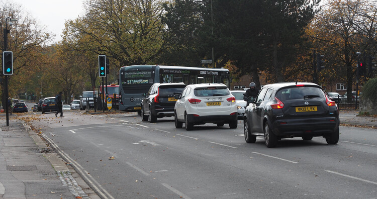
The Marston 8/ CherWell drive junction you mention is an indication of the council's highways officers lack of understanding of the needs of pedestrians and cyclists. It's still pedestrian and cycling unfriendly AFTER being remodeled for the Access to Headington scheme which was supposed to enable active travel. We need to completly retain the highways engineers. I suggested they be taken to Waltham forest to talk to their counter parts there. I was told that officers and councillors had visited, not the right ones apparently m
It's not just the engineers, unfortunately. The county's transport strategy still allows motor traffic optimisation to override provision for other modes, at least on main roads. When these roads are rebuilt, at least inside Oxford, the approach needs to be different: properly provide for walking and cycling first, and then do the best possible for motor traffic with what's left.