
The Charlbury Rd area in north Oxford has a major problem with road danger at school drop-off and pickup times. Large numbers of school-run vehicles arriving and stopping and departing in a short period of time create congestion, along with turning and reversing movements that endanger people walking and cycling.
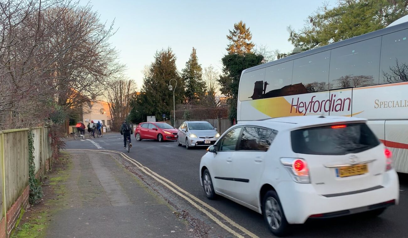
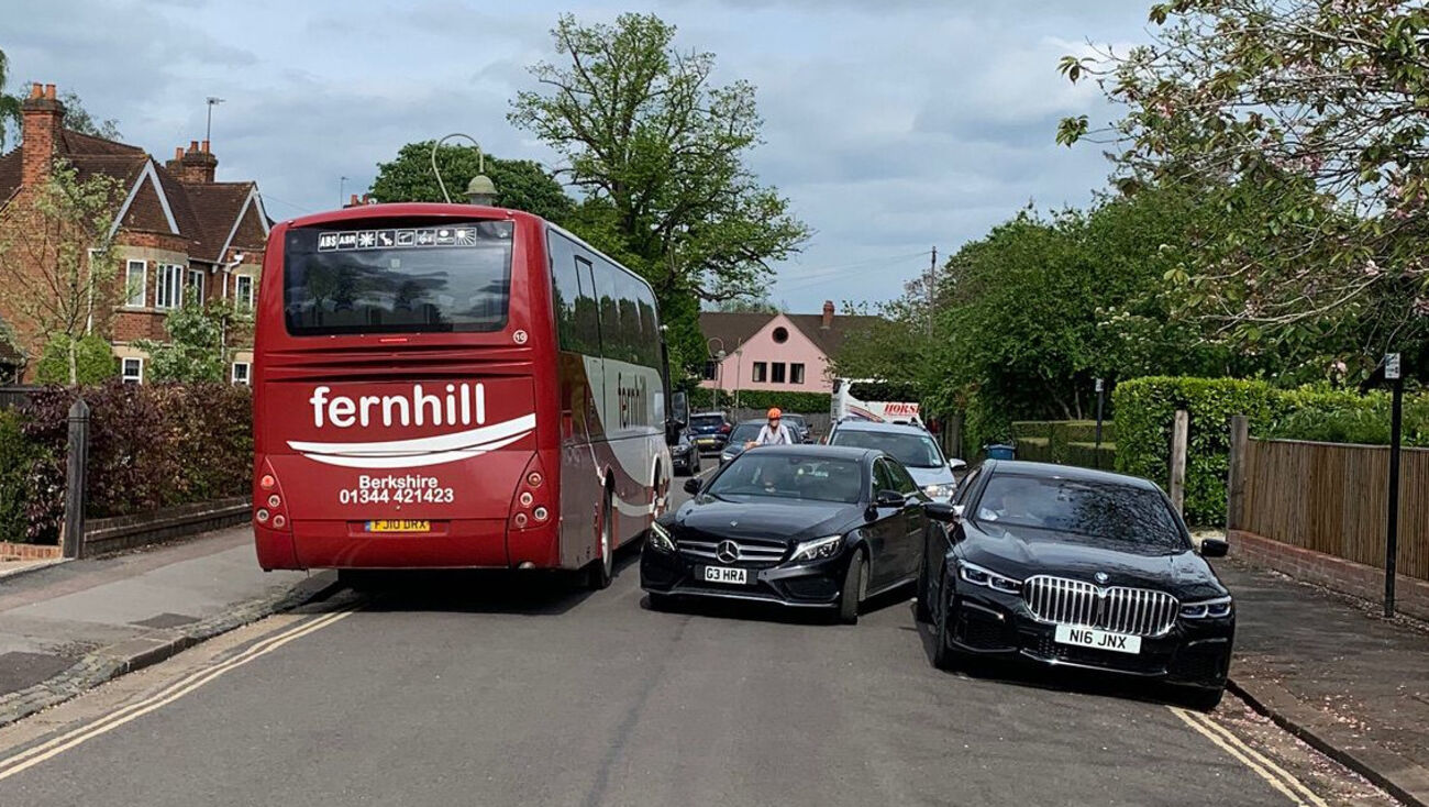
The area also has a problem with coach parking and coach movements. There is some designated coach parking along Charlbury Rd, which was intended for the private school bus service but is used by all kinds of coaches. As well as being hazardous in their own right, coaches take up space and force cycle-car interactions; they also impede visibility.
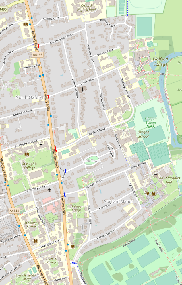
As well as being a key route for children walking or cycling to the schools in the area, the Charlbury Rd area is used by many other people, commuting, going shopping, and so forth. Charlbury Rd itself is part of OXR5 (in the Local Cycling and Walking Infrastructure Plan) and National Cycle Route 51, while LCWIP routes OXN4, OXN5 and OXN6 run west-east into the area. The cycle counter on Dragon Lane records 500+ cycle movements a day.
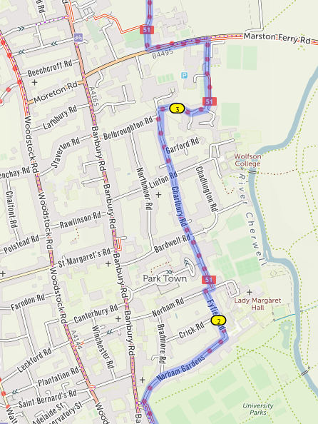 |
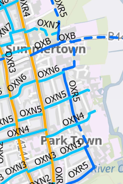
NCN51 (left) and OXR5, OXN6, OXN5 and OXN4 (above)
|
This has been an area of concern for many years, with residents repeatedly raising it with both schools and councillors. I was at a meeting where one resident said they felt unsafe cycling along here themselves, with multiple encounters a week which left them shaking. Another said their teenage child would no longer cycle at all after experiences here and on Banbury Rd.
a solution
 Speeding is a small part of the problem, so traffic calming measures such as speed humps are not a solution. There are infrastructure changes that might help, and which might be flagged by a safety audit of NCN51 that is being undertaken. But these would only address local problems — rebuilding the Bellbroughton-Charlbury junction to make it safer, for example, would do nothing to reduce the danger created by cars turning in the Charlbury cul-de-sac area — and a complete redesign of the area would be very expensive and would only partially solve the problems.
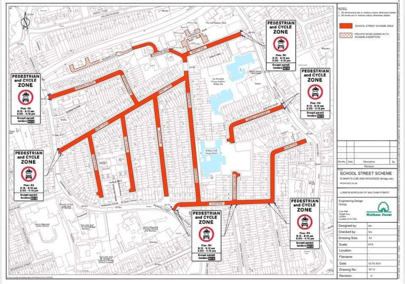
The basic problem is too many motor vehicles accessing a constrained space at the same time, so the most straightforward solution is to prevent most vehicles entering the area at key times, using a School Streets scheme. (The entire area is already a Low Traffic Neighbourhood, so through traffic is not a problem.) This would restrict motor vehicle entry into the area at key times - typically two one-hour periods each school day - to residents, local businesses, blue badge holders, taxis, and other exempted vehicles.
The design of such a scheme is fairly obvious: three ANPR cameras on Bellbroughton, Linton, and Bardwell Rds, at their junctions with Banbury Rd (marked in red on the map above). Any other location would simply shift the congestion and dangerous turning movements, most likely to Northmoor Rd. This would probably need to be accompanied by cameras on Park Town and Norham Gardens and Norham Rd (marked in blue on the map above), to stop road danger being displaced from Bardwell Rd to Benson Place.
A School Streets scheme should be accompanied by a reconsideration of coach parking provision (probably in the context of provision across the city) but would not need to wait on that.
Because a scheme like this involves so many schools (and other institutions), it will only happen if the county takes the lead on it, rather than waiting for the schools to initiate the process.
modal shift and alternatives
By reducing road danger, a scheme like this would enable some children to shift to walking or cycling. It would also encourage patronage of school bus services.
Secondary school children should be able to walk moderate distances to school unaccompanied, and those that can't, for medical or other special needs, would be given exemptions to the School Streets scheme (along with blue badge holders). Children attending Oxford High who need to be transported by car for other reasons could be dropped off in the Ferry Leisure Centre car park and walk from there, using the subway to cross Marston Ferry Rd.
Dragon School children could be dropped off and picked up at the Park Town entry loop, with the school running a supervised walking shuttle if deemed necessary for safeguarding.
And there will be other schemes that could be used to help children get to the schools in the area. But the basic constraint is that it's simply not workable for most to be dropped off by private cars directly at school.
This is an accurate summary of the situation, I and many others have been pushing to make this a safe route to school since 2020 and have concluded that no other measures have worked so a School Streets scheme implemented by the Council with the support of all of the schools concerned is the only viable option .
Excellent work Danny, thankyou
This is a very inaccurate depiction of the school drop off situation and the number of drivers vs students that attend all of these schools. Ultimately the author just does not want this in his back yard, but he is happy to push school traffic onto other neighbouring streets which would then back up traffic across Banbury’s bike lane and bus lane at a busy commute time? Why not start with what would actually be a straightforward path to a solution: a consultation with public and stakeholders in the first instance; during this period the schools are required to more rigorously enforce sensible drop off rules for those who don’t have a biking or walking option (many students are not local to Oxford); raise the fine on drivers in this area to a level it really hurts; and start with sharing views rather than pressing the nuclear button. It is a dangerous precedent to set that the council can use a provision for safe schools to address its grievances with a small number of drivers.
1) There are regular complaints about road danger on Charlbury Rd, to Sustrans and Cyclox and local councillors, from residents, parents, children, and people outside the area using it as a through walking and cycling route. So there is most definitely a problem here.
2) I am not a resident of this area.
3) There may be some displaced traffic, but there are much safer places to have pickups and drop-offs than immediately outside school gates and right on top of a major cycle route. Likely alternatives would also avoid the current turning and reversing movements.
4) There have been numerous conversations with the schools involved over many years, but nothing they have done has achieved anything. And it is a good idea, but it would require national legislation to raise the level of Penalty Charge Notices.
5) School Streets schemes demonstrably work where other measures do not. That's why many other local authorities have committed to putting them in at all schools, and there's funding from the Department for Transport for them.
We can all agree dangerous drivers do a disservice to us all, and thoughtful road safety is good for everyone. But even you must admit you are throwing the baby out with the bathwater here. If the schools in question have not been vocal enough with bad drivers, then they should be responsible for working together, coming to the Council and to parents with tangible, actionable plans that MUST be implemented, and doing so in a certain time frame. Sweeping road closures should be the last resort, and not a display of power.
The Safe Schools Scheme was designed to be utilised by schools and parent groups, not foisted on them by a Council with an ax to grind. In fact Sustrans own best practice document is based on the notion that the school views this as necessary and are pushing for it: building broad based support in partnership with the Council, speaking to all stakeholder, sharing plans widely and with ample opportunity for parent preparation (the opposite of someone stumbling upon a blog post of an individual who doesn't live in the neighbourhood and doesn't appear to have to do school runs). None of these best practices have been put into place. The Council's own website doesn't make clear what is happening. In fact, most parents don't even know this is being considered - and the cameras are already up - so it would be sensible to get everyone on the same page first before creating a chaotic mess.
You do yourself a disservice by pointing to case studies which are wholly different to your proposal. The study of two schools in Birmingham widely circulated by Sustrans shuts off just ONE road in each case, leaving displacement streets connected to the closed road open so that parents who have to drive can park and walk children in safely.
The existing schemes in Oxford are around schools which have local catchment areas. Naturally students tend to live closer and therefore walking/biking/etc is easier to encourage. Your proposal affects not one, but four schools, that have young students coming in from much further afield, where there may not be a bus route and there certainly isn't a safe way for them to bike for an hour during rush hour.
Most of the schemes implemented across the UK (not sure how you define success) are specific to the street(s) leading directly to or in front of a school. You are talking about cutting off everything south of Marston Ferry Road through Norham Gardens. Most of these roads are unconnected to any of the school' entrances. Your plan provides for zero displacement streets to be used by those who must drive, park and unload children (and the thousands of things schools require them to bring in each day) safely.
The idea that the Park Town Crescent is a safe and appropriate drop off zone for kids to walk unaccompanied defies logic. Some of these kids are in Reception and are 4 years old (!!) (Dragon siblings that take the shuttle from the Prep each morning, and OHS pre-prep girls to be moved to Bardwell shortly). This goes against the country's own child safeguarding policies and is unacceptable.
You and I clearly have different perspectives, but we can all agree that (1) rude and dangerous driving and parking is unacceptable, (2) the schools have a responsibility to send a clear message or penalise the minority of drivers who are ruining it for everyone; and (3) it is both right and respectful if considering sweeping, potentially dangerous changes to road usage to provide an opportunity for all impacted to share their views and to find a solution.
Frankly, I think you and I could probably hammer something out over a coffee. It would also be more efficient than all this writing...
Ultimately, the Council imposing its will on the neighbourhood and the broader community is not acceptable.
As with congestion and road danger elsewhere, the problem is not just driver behaviour, it is too many vehicles trying to use narrow streets at once. Any solution has to reduce the number of cars trying to use Charlbury Rd at peak times, and particularly having to turn or reverse there.
Decades of schools asking parents to drive more considerately has not worked, here or elsewhere in Oxford (or indeed around the country).
The broader community is, generally, hugely supportive of School Streets schemes - they are more popular than pretty much any other transport schemes. The first round of School Streets schemes in Oxford had 88% support at consultation (and there were over 300 responses).