In 1999, the council blocked cycling (in the middle of the day) on Cornmarket and the eastern end of Queen St; in 2017, with the redevelopment of the Westgate Centre, cycling was blocked at the same hours on Turn Again Lane; and then in 2022 cycling was blocked at the eastern end of St Michaels St. And now the county seems likely to ban cycling on a further 30 metres of Market St. This progressive removal of cycling routes has left no safe and inclusively accessible east-west cycling route through the city centre. High St and St Aldates have way too many buses, Pembroke St is unusable without a horrible dog-leg across St Aldates, and while George St is not so bad it still has too many buses, with turning movements.
Many people simply won't cycle on these routes, or let their children cycle on them. So if the councils are at all serious about enabling cycling, or about equity and inclusivity (and the Local Transport and Connectivity Plan has a goal of increasing cycling trips by 60% by 2030), then there has to be a fully accessible east-west route across the city centre. (I have previously written about the need to support inclusive cycling.) The most sensible way to achieve this is, in my opinion, to allow cycling at all times of day on Queen St and Cornmarket, but there are different options.
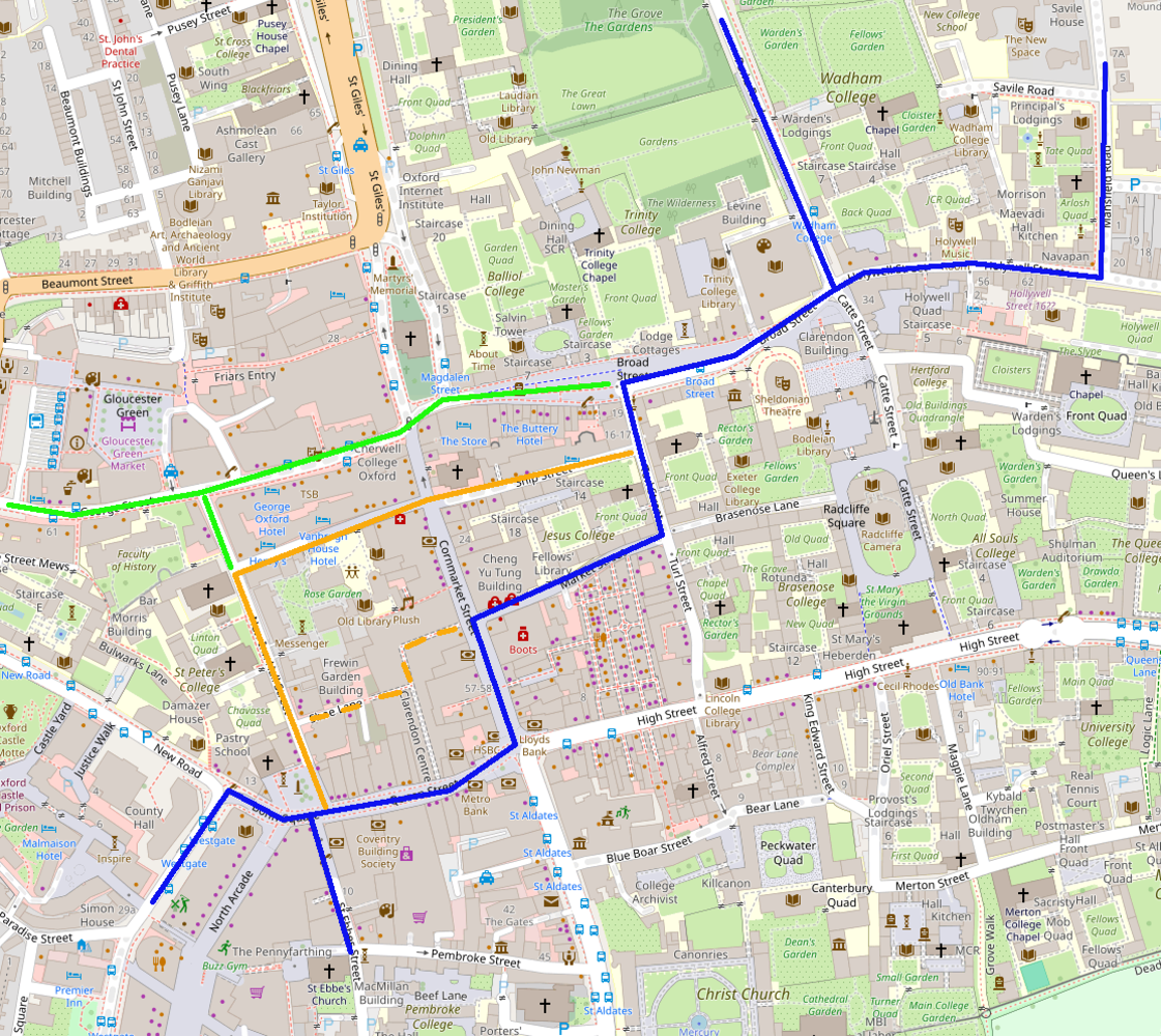
1. Allow cycling at all times of the day on Queen St and at least the southern half of Cornmarket, enabling the route as shown in blue on the map above. This is the route used by the "bike bus" from South Oxford to Swan School in the morning, but they can't use this on their return trip in the afternoon.
2. Reverse the cycling ban on St Michaels St, remove the outdoor seating there, and use St Michaels St plus Ship St — with cycling allowed across Cornmarket to connect them (as across Queen St from St Ebbes to New Inn Hall St) — to create a "cycle street". This is the route that used to be the marked "quiet route" across the city centre, as shown in the map below.
3. Move the bus station to Becket St, relocate buses from George St to Beaumont St, and move the bus stops on Magdalen Sts East and West to St Giles. This would be the best option, ideally as part of a broader walking and cycling route all the way from the railway station to Magdalen Bridge, but is a long term prospect.
4. Get the Clarendon development to include a cycle route from Shoe Lane through to Cornmarket, as shown in the dashed orange line. Together with Market St, and allowing cycling across Cornmarket to connect them, this would provide an east-west cycle route. This is worth investigating, but does seem rather unlikely.
So what are the problems?
Cycling is already allowed on the western half of Queen St (Bonn Square), and on the other half of Queen St and on Cornmarket before 10am and after 6pm. This creates no significant problems. Yes, there are some complaints from pedestrians (often not understanding that cycling is allowed) and from people cycling (there is almost no signage to mark National Cycle Route 5 running across Queen St from St Ebbes to New Inn Hall St), but given the huge numbers of pedestrians and high numbers of people cycling (up to 2500/day at the western end of Queen St), not very many. So the question is not whether cycling at all times of day is workable, but what the tradeoffs are.
Here, note that anyone cycling on Cornmarket is not cycling on New Inn Hall St or Turl St, so the downsides of additional cycle-pedestrian conflicts on Cornmarket are offset by reducing cycle-pedestrian conflicts there. Turl St in particular sees significantly worse foot-cycle conflicts than Cornmarket, largely because it is so much narrower. (If allowing all-day cycling on Cornmarket and Queen St enables some cycling trips that wouldn't otherwise have happened at all, that would be a huge gain.)
The following measures could be taken to reduce conflicts:
- Better pedestrian priority signage. Advisory 5mph speed limits (if allowed). Better signing of National Cycle Route 5 from St Ebbes to New Inn Hall St.
- A complete redesign of Carfax, to better support pedestrian and cycle movements.
- Better enforcement against illegal unregistered mopeds (pretending to be e-bikes but with overpowered motors).
- Removal of street clutter, on Queen St and Cornmarket but also on alternative routes.
- Improvements to alternative routes: a cycle crossing across High St from Turl St to Alfred St and resurfacing of the latter to be safe for cycling; measures to stop parking right at the southern end of New Inn Hall St, where it blocks the street; a layout for Turl St like that of New Inn Hall St or Pembroke St, removing the largely ignored but hazardous kerbs; etc.