
Oxford's Lye Valley area has poor walking and cycling connectivity, making it one of the more car dependent areas inside the ring-road (looking at 2011 census commute data). Two key routes could be upgraded to improve this, to the west across Lye Valley to the Churchill Hospital and to the south west over the golf course.
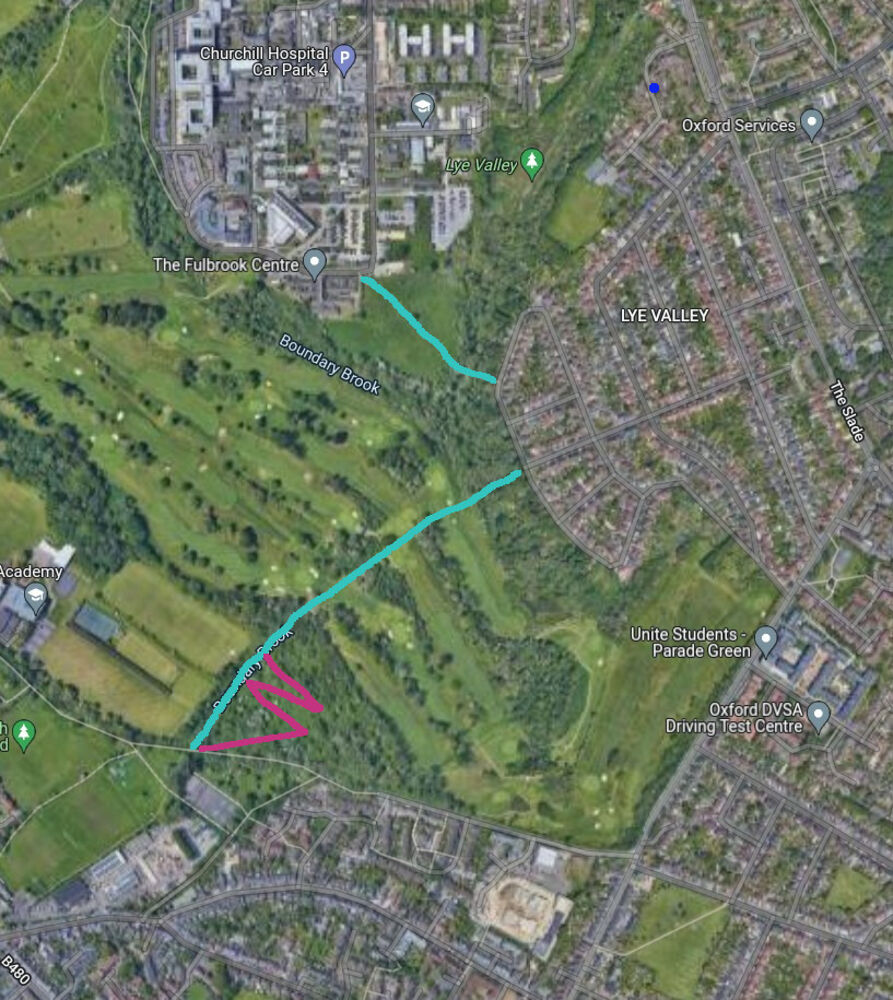
1) Put a proper foot-cycle track, with a bridge, across Lye Brook to the Churchill Hospital. 2) Upgrade the track across the golf course to Barracks Lane to an all-weather foot-cycle track, with a bridge across Boundary Brook to connect to Lye valley and potentially with zig-zags on the descent to Barracks Lane. This would require a legal change from a footpath to a bridleway. The likely form of any track would be a 3 metre wide shared path, with porous surfacing and embedded stud lighting, along the lines of the ones being put in across parks and fields elsewhere (e.g. across King Georges Field).)
As well as providing connectivity for residents of Lye Valley, these links would also improve connectivity for people in Wood Farm, Slade Park, and so forth, as well as people in Cowley trying to reach the Churchill Hospital and other destinations in Headington.
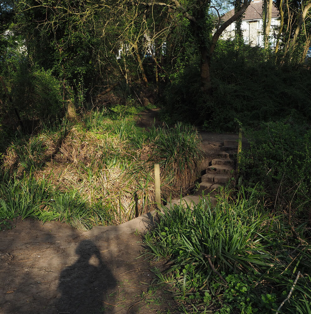
A Bridge across Lye Brook
There is a route here already, but it is unsurfaced and uneven and involves clambering down and then up five metres - it is unsuitable for cycles and mobility scooters, anyone with a pram or stroller or in a wheelchair, or indeed anyone not up to tackling what is effectively a hiking track.
A proper track here, using a bridge to stay "at grade", would improve walking and cycling connectivity to the Churchill Hospital, and beyond that to the Old Rd Campus, the Warneford Hospital, Cheney School and Brookes University. It would also provide access to bus services from the Churchill, most obviously the Stagecoach 700 (connecting to Thornhill one way and to Marston, Summertown, Oxford Parkway, and Kidlington the other). For best effect, this scheme would be combined with better active travel provision within the Churchill Hospital site itself, which currently has poor footways and cycling provision. Better support for cycling on Roosevelt Drive would also help.
A bridge here would be outside the Lye Valley Site of Special Scientific Interest. And even with increased use it would probably reduce the impact on the environment, by keeping people away from the bed of the brook and reducing erosion of its banks. The major ecological risk would likely be during construction, which would have to be carefully planned and managed.
A bridge would be moderately expensive, but not remotely as expensive as putting bridges across the Thames and much cheaper than any road-building schemes.
A track across the golf course
Again, a route exists here already, but it's not accessible for people cycling or wheeling, or for many people on foot. Surfacing a proper foot-cycle track across the golf course would be relatively straightforward. Putting in a bridge across Boundary Brook and some kind of zig-zag descent to Barracks Lane would be more complicated but, again, would require nothing unusual. This would provide a walking and cycling route between Lye Valley and Temple Cowley / Cowley Marsh, but would also enable connections between Wood Farm and Slade Park to the north and Cowley and Florence Park to the south. (Examples of cycle tracks across golf courses)
The area is also relatively poorly served by bus routes. The number 10 bus runs down its eastern edge, along the Slade and Hollow Way, and the number 15 bus touches its northern corner. Looking at the commute data from the 2011 census, it is one of the most car-dependent areas of Oxford.
The Hollow Way Traffic Filter (a version with far fewer exemptions, aka a Climate-Control-Point) would do a huge amount to connect this area to Cowley -- possibly enough to make the golf-course option redundant.
Opening up Hollow Way for cycling would help a lot - depending on how many exemptions there are and how much traffic there still is. But it's still a large detour for many trips - most obviously for walking, where 500 metres extra distance is a lot for many people.
Is there a public right of way across the golf course? From the satellite picture it looks more like a desire path and doubtless the golf course would object to having it paved over for public use much as I'd support it. I don't know if there is any way to force the matter.
Likewise as you walk from the LV trail onto the Churchill campus there are signs saying private property etc, presumably only the landowners would have to agree to a new route or at least support it (more likely in that case I'd suspect).
Living in the area I do think this would be very useful. One issue cycling in from Cowley road is that the Cowley marsh bike track is very nice but the barracks lane end is *very steep*, you see a lot of puffed out cyclists at the top!
The golf course route is marked on the Ordnance Survey map as a right of way, but of course that doesn't allow cycling. I think the owners are the city council, but the golf course might have some say as well. The hospital route isn't marked on the OS map, and as you say is presumably owned by the NHS trust.
The Barracks Lane climb is indeed rather steep (memories of yelling "push harder" at my daughter on the tandem), hence my idea of putting in a zig-zag to avoid anything like that.
The golf course land is owned by Magdalen College and the club has a 60 year lease expiring in December 2039 (I paid the £3 to get the Land Registry record).
The council map at https://publicrightsofway.oxfordshire.gov.uk/ shows the (known) rights of way. The network around there, apart from Barracks Lane itself, is footpaths, rather than bridleways.
So the golf course route would need Magdalen College to create a permissive bridleway? And presumably it could be upgraded as a footpath without that.