Most of the questions about Oxford's proposed traffic filters and congestion charge are covered in the consultation FAQ, but here are a few that aren't:
- Isn't it pointless putting traffic filters on St Cross St, Hythe Bridge St, or Thames St, because there are hardly any buses there?
- All the traffic going through the St Cross filter is also going over Magdalen Bridge, which is the busiest bus route in the entire United Kingdom. All the traffic on Hythe Bridge St is traversing Frideswide Square, which is a major bus route, and most of it is also going through St Giles. And all the traffic on Thames St is also using Abingdon Rd, which is a major bus route. All of these routes also suffer significant congestion. more
A scheme for High St should be included in the Central Oxford Movement and Place Framework. High St is a major pedestrian corridor, hosts a large number of shops, is a major bus corridor with some of the busiest bus stops in the city, and is a cycle route used by over three thousand people a day.
But High St has never been designed for this mix of uses: it still has pretty much the same layout it had before the bus gate was put in in 1999. It is poor for walking (the footways are too narrow and crossing the wide carriageway with buses blocking visibility can be a real challenge), poor to terrifying for cycling, and far from ideal for bus services, either for bus movement or for passenger boarding and alighting. And the cramped footways and poor visibility can make accessing - or even finding - the shops difficult.

road injuries on High St, 2014-2023
more
There is a consultation on removing the parking on Hollow Way to reduce congestion, with reducing bus delays as the main motivation.
"There are longstanding issues on Hollow Way, where its narrow width coupled with on-street parking create congestion and a safety risk as there is not sufficient space for vehicles to easily pass one another. This is a particular issue for local bus services who regularly use the route and report regular delays. The issue also leads to traffic congestion and makes it more difficult for residents and businesses on the road."
But this illustrates how moto-normative transport planning still is, even in Oxford. The only gains considered are congestion reduction and safety for vehicles, which are balanced against the loss of parking for residents and businesses.
There is no mention of walking, wheeling or cycling, or of Vision Zero; nor are the broader effects on the lives of people considered. There is no discussion of traffic speed, though one of the central concerns with removing the parking is that it will result in people driving faster. And there is no mention of air pollution or noise pollution, which the scheme is likely to make better in some locations and worse in others.
more
We used the trains quite a bit on our mid-2023 trip to Sydney, and Helen learned the order of stations on Sydney's North Shore line, from Central to Hornsby (including the three Ws at the end, which surely exist only to make this a challenge). more
The Oxfordshire policy on 20mph speed limits says that to be eligible an area must "be within the extent of the built-up environment of the town or village where vulnerable road users and vehicles mix in a frequent and planned manner" and "be in an environment that explains and justifies a lower speed limit to the driver".
A small addition to this would I think make sense. There are sections of road which are not within a built-up area, but which are key walking or cycling links. They may link a village to a bus stop or a strategic cycling route, for example, or an outlying housing cluster (hamlet) to a village centre, or a school to a town centre. Where such sections of road are relatively short and lower speeds would make a significant difference, perhaps because there are no footways or cycling infrastructure, or because crossings are necessary, I think they should be included in the scope of the 20mph policy. more
I think consideration should be given to turning off the signals at the northern end of Cornmarket and having that junction operate like the Holywell junction at the other end of Broad St.

I walk and cycle through this junction regularly, and there's pretty much always:
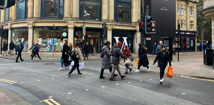
- a stream of pedestrians crossing on red across George St, as in the photo above - if they didn't they'd pile up and block the footways;
- pedestrians crossing haphazardly across the unsignalled Magdalen St West and Broad St arms, sometimes getting caught out mid-crossing by signal changes;
- mopeds and cycles going through red lights or using the wrong side of the road to turn from Broad St into Magdalen St West; and
- significant periods when buses and taxis and cycles are waiting even though the junction is clear.
more
With 51 people scheduled to speak for two minutes each, followed by the cabinet members themselves speaking (and debating amendments), it was a long and lively cabinet meeting to decide on adoption of the Central Oxfordshire Travel Plan and the traffic filters in that. Roughly half the public speakers were against the traffic filters, a quarter were for them, and the other quarter wanted tweaks: Kennington or Noke to be given more permits, this filter or that to be dropped from the scheme. more
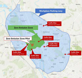
How should the planned Oxford traffic filters work: what hours should they operate, what exemptions should there be, and so forth? To understand this, we need to understand their purposes:
- to allow space and time to be reallocated to make walking and cycling safe and accessible, especially at junctions
- to stop buses being congested and delayed, to have better and more efficient bus services
- to free up space (and reduce noise and air pollution) for an improved public realm
But while the goals may be the same, the unique geography of each filter — and the very different roads they are on — means that they may need quite different implementations. This can be illustrated by Hythe Bridge St and Marston Ferry Rd. more
Oxfordshire was recently awarded central government funding, under the ZEBRA program, to electrify Oxford's local bus services. Looking at the full business case for this, two things are clear:
- The ZEBRA funding for bus electrification is contingent on the traffic filters in Connecting Oxford.
- If we don't get the ZEBRA funding, we're not just going to miss out on electric buses - we're going to be facing cuts to bus services.
Here are some quotes from the business case, with some key bits in bold: more
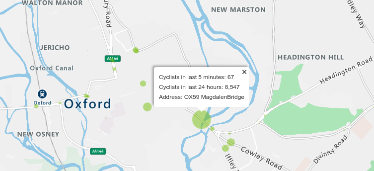
Oxford's Magdalen Bridge is plausibly the second busiest cycle route and the busiest bus route in the United Kingdom; it is also a major pedestrian route. It is probably the most critical link in the city's transport system.
more
Connecting Oxford is absolutely central to Oxford's transport future. The new county government had been quiet about it until recently, but has made a clear commitment to it in the last few months. It is unclear how much of the details on the old web site are still current, but some of my thoughts on how to prepare for Connecting Oxford follow.
The Local Transport and Connectivity Plan (LTCP) adopted in October 2021 said:
"Work on aspects of Connecting Oxford has already started. The aim is to have the workplace parking levy and traffic filters in place from 2023."
And the lead request for funding in the Bus Services Improvement Plan (BSIP) is for the traffic filters in Connecting Oxford. more
The designs proposed for Woodstock Rd will be a huge improvement for walking and cycling.

The cycling provision will be taken off pavements, allowing for 2 metre wide footways. At some minor side entries there will be fully continuous pavements giving people walking unquestionable priority. Turning radii at side entries will be tightened, shortening crossing distances and slowing motor traffic. And five additional signalled crossings are planned.
If this scheme goes ahead as designed, Woodstock Rd will have the best cycling provision on any Oxford arterial route. It is not clear from the plans, but if I understand rightly the scheme involves stepped cycle tracks. These will be 2.2m wide for most of the route, will have clear priority over side entries, and will bypass bus stops, avoiding forced rejoins with the carriageway. The fundamental change is that cycling is now neither on the carriageway nor on the pavement, but given full recognition in its own right.
It's not perfect. Due to space limitations, there are places where the pavement is under 2m wide — 1.8m at the narrowest — and there's a fairly long stretch where the cycle track is only 1.7m wide. (The pavements have been prioritised here, only dropping below 2m when necessary to stop cycle tracks being narrower than 1.7m.) There are also a few "shared space" sections, due to constrained space around bus stops, to support less confident people cycling across Woodstock Rd, and (probably) to avoid having to remove trees. more
As part of the emergency active travel funding, the cycle tracks on Magdalen Bridge have been widened. On Wednesday evening (August 5) I went and had a look at the changes for myself. There I ran into Chris (Pedal&Post) and we watched the interactions between motor traffic and people cycling for maybe half an hour, from 5.30 to 6pm. more
Bicycles have featured a lot in my blog, but the other key to sustainable transport, in Oxford as in much of the world, is the bus. Buses are central to Oxford's existing transport and will need to play an even bigger role in any sustainable future. More generally, such a future requires the world to transition away from private motor vehicles, with perhaps an 80% reduction in car miles in the UK, and the bulk of that transport "hole" will have to be filled by bicycles and buses. more


