Oxford already has a lot of low traffic neighbourhoods, without through routes for motor traffic (which is restricted to access). Some of these are "natural", in that they were effectively created by the geography, but new areas of housing are built as low traffic neighbourhoods — no one designs residential streets that will attract through traffic — and others have been retrospectively implemented by modal filters, usually bollards or gates. Here I document some of the latter.
The question for anyone opposing low traffic neighbourhoods is, are you also asking for these existing ones to be turned back into High Traffic Neighbourhoods? And if not, why not - what differences justify massively higher traffic volumes in Bartholemew and Crescent Rds than in Phipps and Freelands Rds?

East Oxford
Modal filters on Addison Cresecent and Meadow Lane (north) prevent the use of Iffley Fields as a rat-run to avoid the traffic lights at the Donnington-Iffley intersection. Barriers on Meadow Lane (south) and Freelands Rd provide the same protection to Donnington and Iffley Village.
[Click on the map for a larger version. Modal filters are marked in red.]
Also note that there is no way to drive directly between Iffley Village and Rose Hill.
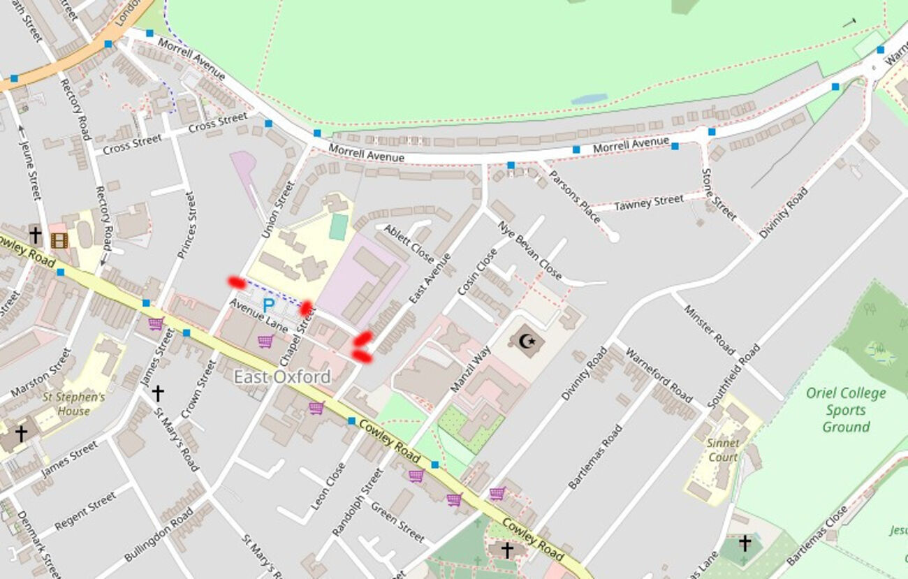
There are no through routes from Morrell Ave to Cowley Rd in between Divinity Rd and Cross St/Princes St. This low traffic area was created in the 1990s1985 using gates and bollards on Union St and East Ave/Collins St.
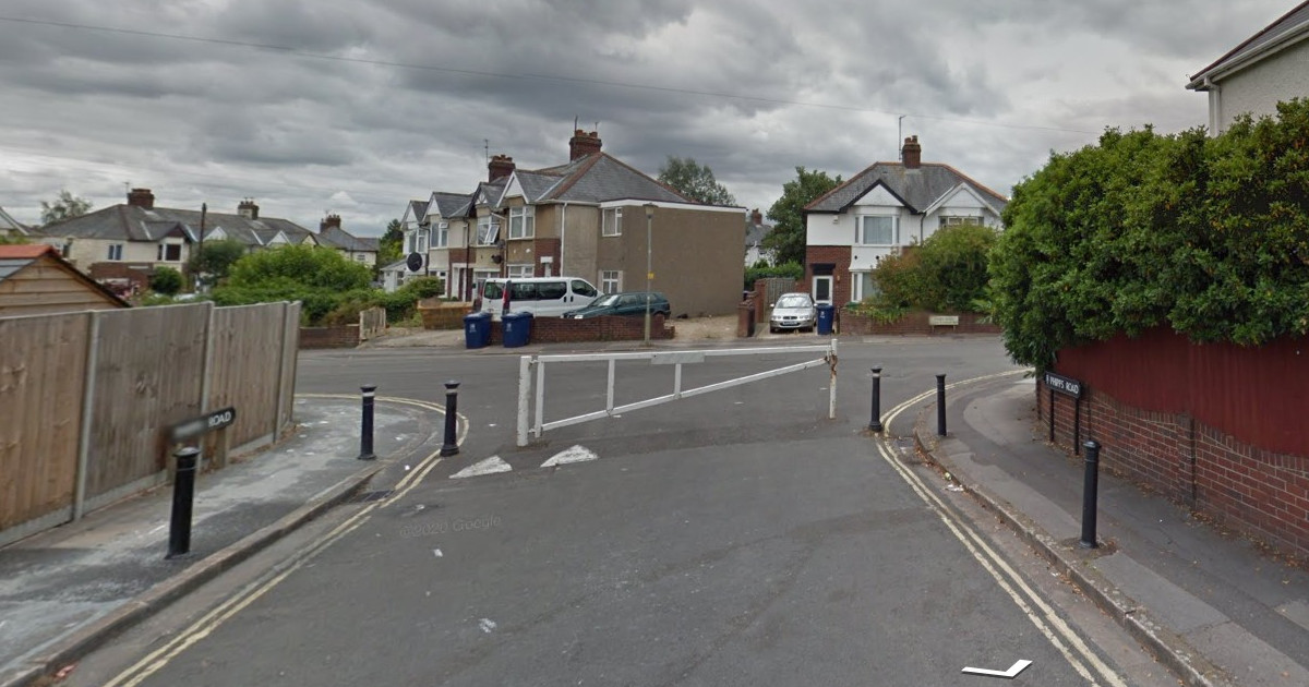
A gate on Phipps Rd stops cut-throughs from the B480 to Barns Rd and creates a low traffic neighbourhood. A one-way restriction and a no-right-turn sign stop St Luke's Rd being used as a rat-run.
 |
South Oxford
Potential cut-throughs around the junction of Weirs Lane and Abingdon Rd have been stopped by modal filters on Canning Crescent and Fox Crescent. Wytham St is also filtered where it meets Abingdon Rd, though that is presumably to simplify the junction.
 |
North Oxford
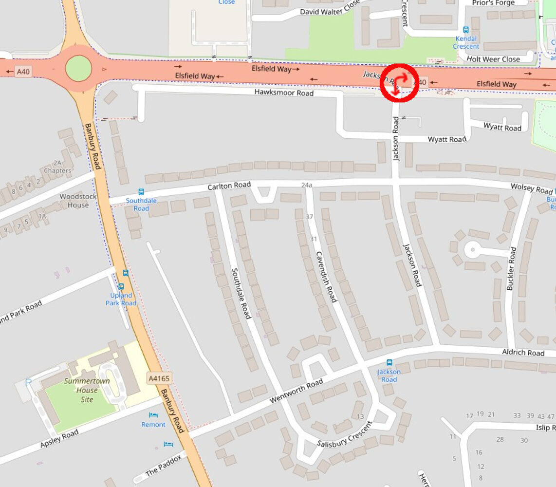
No Right Turn and No Left Turn restrictions (out of and into Jackson Rd) prevent short-cutting to avoid the Cutteslowe roundabout and make the entire Sunnymead area an LTN. The carriageway is curved and bollards used to encourage compliance with those restrictions.
 |
These bollards on Holt Weer Close make Cutteslowe a low traffic neighbourhood.
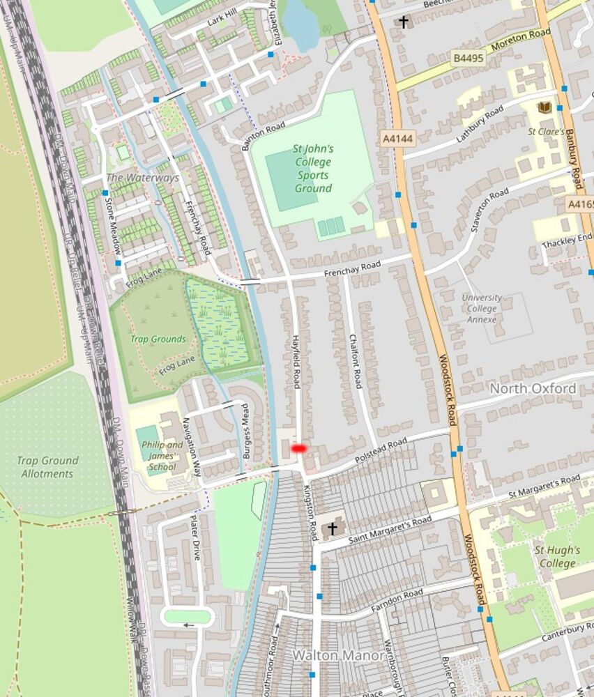
This gate on Hayfield Rd (and the one-way routing of Polstead Rd) makes the area to the north a low traffic neighbourhood; it also helps keep motor traffic off a key cycling route.
 |
Bollards make sure the are no through routes in the Waterways area.
Headington and Marston
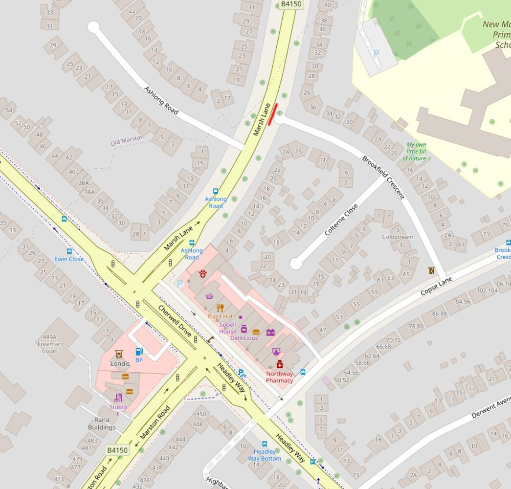
Brookfield Crescent is blocked by bollards, preventing it being used as a short-cut around the B4150-B4495 junction. Not very effectively, through traffic is barred from Ellsfield Rd and Elms Dr by "Except Access" signs.
 |
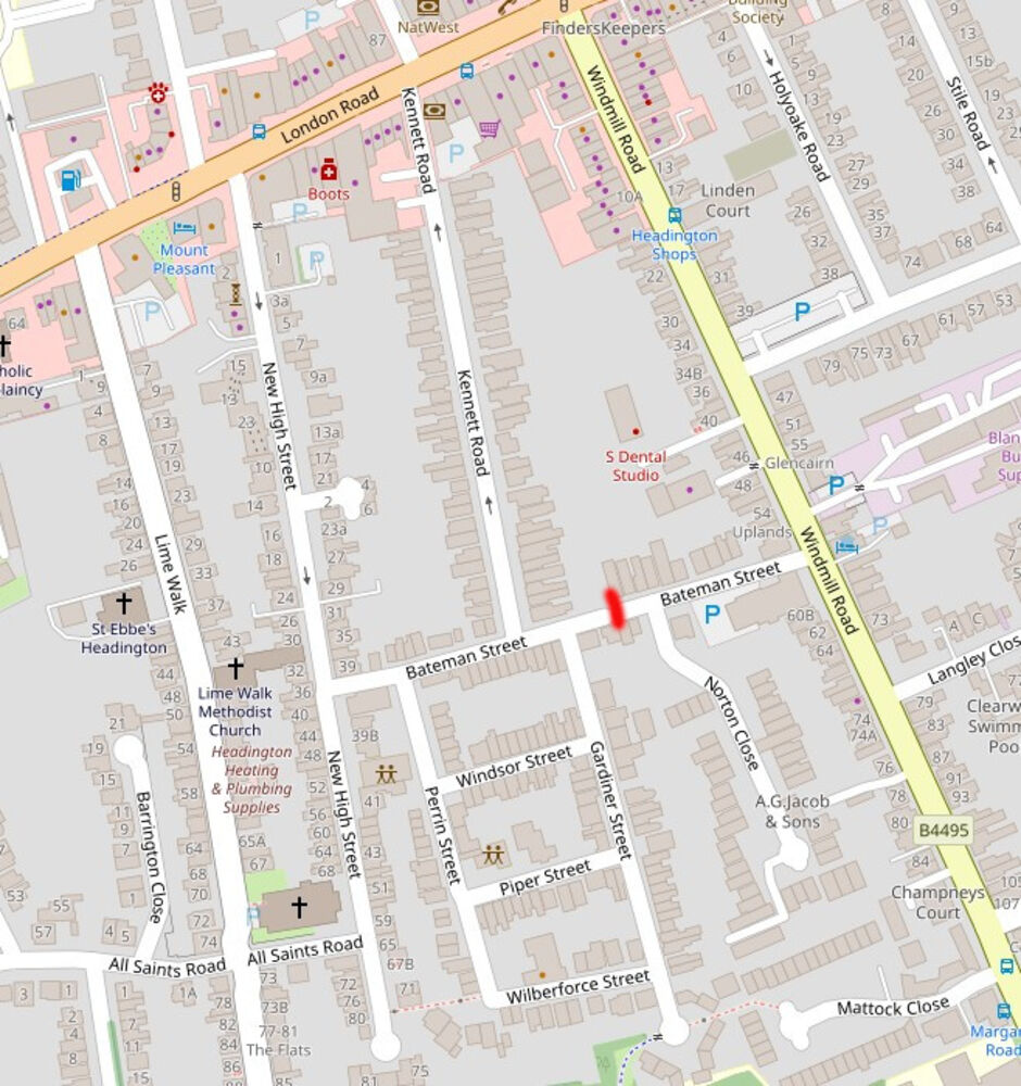
Bollards on Bateman St create part of a low traffic neighbourhood.
 |
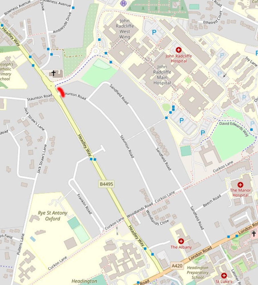
A filter on Staunton Rd creates an incomplete low traffic neighbourhood. It's still possible to use Woodlands and Sandfield to avoid the Headley Way-London Rd traffic lights, but Staunton and most of Sandfield are protected from through traffic.
 |
A much more comprehensive survey of Headington LTNs.
back to East Oxford and Cowley
And here's a map by Scott Urban showing East Oxford's LTNs, old (pink) and new (purple and yellow). If you include the "natural" low traffic neighbourhoods, it's clear that "Normal Traffic Neighbourhoods" are actually the norm, with just a few remaining "High Traffic Neighbourhoods".
This is excellent! I guess we need to rip out all these filters. How are the people in these neighbourhoods coping???
The East Avenue and Union Street filters are from the 1985 3-month experiment -- bit earlier than 1990s.
Brilliant. Thanks Danny. It would be great to map the whole city as apart from Jericho much of the residential areas between Woodstock Road and the canal and Banbury Road and the Cherwell are LTNs as well.. Could someone work out for us what percentage of Oxford’s population is already living in an LTN? It is probably quite high.
Arguably Glanville Road and Cumberland Road are not low-traffic as they are used as a circuit for collect and drop-off at Oxford Spires Academy. A nice school street scheme here would fix that beautifully!
The so called ltn in Philips road could now be removed happily as it was put in to stop traffic from the factory accessing blackbirdleys, Littlemore and rosehill at a time when the plant had thousands more working there than do now, keep closing main arteries is causing major disruption in cowley and extending journey times and fuel use considerably, we can't all use cycles or afford electric vehicles, as usual occ trying to bully people into accepting its views .
There are still a lot of people working in the business parks - and probably a larger fraction of them have cars now than workers did twenty years ago. I'm pretty sure if the Phipps gate were removed there'd be thousands of people a day using this as a route to by pass the B4495, and it would need to be put back for the same reason it was put in.
Thanks for this! Worth pointing out that some of the rat-runs cross from one zone to another, eg Longwall Street's opposite number, the "Southern Ring Road", that goes from the west end of South Park, left along either 1) Morrell Avenue, Cross St and Princes St, or 2) along Rectory Road, then over Cowley Road and usually along James Street, jamming the crossing by Cowley Road Sainsbury. From James St it takes Iffley Road and Donnington Bridge.
Blocking Princes St(& probably Rectory Road) would "fix" two potential LTNs at once as well as greatly improving traffic flow on northern Cowley Road. Bring It On!
On the "way before it's time" school street rising bollard protecting Phil and Jim primary school, as a parent there for the last four years I can confirm the rising bollard has been broken for at least three years. And of course it's been reported, dozens of times. A three or four times at the beginning of the school year a traffic warden guarded the spot during morning school run, but that's all.
An ANPR-reading camera would require no maintenance and pay for itself in seconds. (Ok, a few months!)
Was asking some residents in the sides streets off Botley Road - almost all of which are narrow dead ends how services like waste and recycling collections managed.
No problem, apparently. Trucks either drive down or reverse down as far as they can comfortably go to then wheel bins the rest of the way.
It is fine to have a consultation and to use those those comments to modify schemes ( or even rescind them) but that assumes that the LTN's are operating as intended. Around Cowley nor motor cycle or moped adheres to the regulations and we have yet to see any sign of a bus gate camera on the Bartholomew road 'Gate'. It is 'business as usual ! How can any realistic assessment be made in the circumstances ? If Littlemore Road was reopened as a through road and Bartholomew Road restricted to cycles etc., we could have a school street without any great additional disruption and no need for any cameras, as well as improving traffic flow. Littlemore Road residents may object but this road has always been a 'through road' so they can't really object to traffic using it.
Re Wytham St:
I would guess that this is also filtered so people don't cut in here, drive up a few streets and out again when the traffic is dire. (Or vice versa in a southwards direction)
[…] Oxfordshire, even though they may not have been called this. For Oxford, Danny Yee has compiled a list of existing LTNs. For example Freelands Road, filtered to traffic in 2002 after a 4-year old girl was injured by a […]