
Oxfordshire County Council has proposed a range of "Quickways" measures designed to improve cycling on some of Oxford's main roads — Iffley Rd, Cowley Rd, Marston Rd, Between Towns Rd, Morrell Av, Warneford Lane, Parks Rd, Banbury Rd and St Giles — using Active Travel Fund money from the Department for Transport. These measures are limited in ambition and in many ways sub-standard, but some of them are major improvements and others are reasonable if seen as temporary measures to be put in place until funding is available for more substantial engineering, or as derogations that are unavoidable because of physical constraints.
The scheme measures largely follow measures proposed in the Oxford Local Cycling and Wallking Infrastructure Plan (LCWIP). They are constrained by the need for rapid implementation, dictated by the funding from Active Travel Fund Tranche 2, and by the limited amount of that funding — quite a considerable sum, but spread out over a large area. So they mostly involve signs and paint on road surfaces, with some bolt-on wands and orcas, and largely eschew any kind of "hard" engineering: moving kerb lines, relocating pickup loops at junctions, putting in continuous pavements, or other such changes. (A few "islands" are installed or removed, and one pedestrian crossing put in.)
Many people are disappointed at how little physical separation from motor traffic these measures provide, and few of them meet the standards set out in "Cycle Infrastructure Design, LTN 1/20". In some cases this is unavoidable due to width constraints; in others full road rebuilds at a future date will allow improvements.
Major gains
Removal of on-street parking
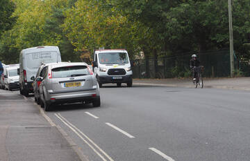
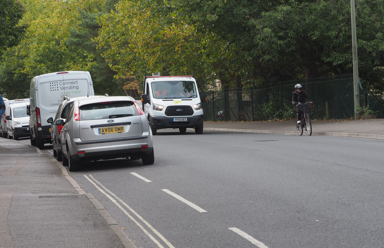
There are many places where parked vehicles interrupt cycle lanes, forcing people cycling to merge with motor traffic and creating dooring risks, or take the space needed to provide cycle lanes at all. There are also places where parking dangerously restricts visibility. Removal of parking enables the biggest gains from the Quickways schemes.
- On Iffley Rd cycle lane continuity will be drastically improved, especially outbound. Removal of parking will also improve visibility, for example when turning right out of James St onto Iffley Rd, where parked cars currently block the view of traffic approaching from the south.
- On Warneford Lane, removal of the parking will allow proper cycle tracks to be put in, avoiding people cycling having to choose between using the unfit for purpose cycle lane, which combines dooring risks with multiple close-passes, and facing driver aggression for taking primary position in the centre of the carriageway.
- On Morrell Avenue, parking removal will allow the creation of an uphill cycle lane. This will greatly assist people cycling slowly up the hill, because they won't have to stop and start because of parked cars and traffic merges.
- Cycle lanes on parts of Cowley Rd, Donnington Bridge Rd, Marston Rd, and Church Cowley Rd will also have better continuity.
- On the narrowest stretch of the B480 (Oxford Rd Cowley), the removal of parking won't create enough room for cycle lanes, but will improve visibility and improve the smoothness of general traffic flows (for motor traffic as well).
There will need to be solid enforcement of the new restrictions. A major concern will be temporary parking - for deliveries or loading, or by blue badge holders - undoing much of these gains. More extensive use of mandatory cycle lanes would help here. Another suggestion is to make the busiest inner sections of these routes urban clearways or red routes during peak hours. (These sections are also critical for connnecting to "quiet" routes, for example Iffley Rd from the Plain to James St and Jackdaw Lane.) This could be coupled with the provision of disabled and short-term loading spaces as the first parking places in side streets.
Another risk is that, unconstrained by parked cars, motor traffic will speed up. Traffic on Morrell Avenue is perhaps most constrained by parking at the moment, so may be at the greatest risk of higher speeds once that is removed.
20mph speed limit extensions
20mph speeds will reduce the severity of injuries in the event of collisions and reduce air pollution. They will make cycling through junctions easier, most obviously with right turns. And they will make crossings by pedestrians safer and easier. Compliance with the 20mph limit will obviously be a concern, as it is in the existing 20mph areas, but the lower speed limit is likely to have some effect on speeds and seems unlikely to make things worse.
The road designs need to make 20mph a natural speed. The constrained carriageways from expanded cycle lanes will help, but that would be much more effective with wands, or at least mandatory rather than advisory lanes. Colouring of the cycle lanes would also help.
The scope of the 20mph extensions seems unnecessarily complicated. There are too many speed changes along the B4495 in the proposed layout: someone driving from Lye Valley to the railway station, for example, will face eight changes of speed limit, which hardly seems conducive to compliance. It would be simpler and more coherent to make the whole of that "inner ring" route 20mph, keeping just the outer stretches of Abingdon, Iffley, and Cowley Rds at 30mph. This would make the Rose Hill and Weirs Lane-Abgindon Rd junctions 20mph - the latter is a particularly bad collision hot-spot.
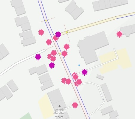
collisions at Weirs Lane-Abingdon Rd
|
some physical separation
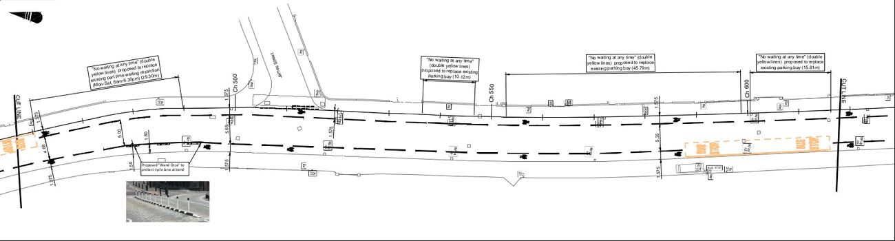
Some stretches of the routes will have wand-orcas preventing overruns by motor traffic. The longest stretch by far is Warneford Lane, but there are also decent protected sections on St Clements and Between Towns Rd, along with one short section on Iffley Rd (to prevent drivers cutting across a bend).
These will prevent encroachment by motor vehicles and should deter parking (though some stretches may need additional bollards/wands to stop vehicles simply driving into the cycle lanes). They will also help to narrow the carriageway and reduce traffic speeds.
The use of wands also sets a precedent for possible schemes elsewhere in the city.
Wider cycle lanes
One of the most obvious changes is the widening of the cycle lanes. This should make cycling feel more secure, and help increase passing distances (since many drivers "drive to the line" rather than waiting for a gap in on-coming traffic so they can give cycles proper clearance).
In places this involves reducing the marked carriageway below the 5.5 metre minimum necessary for two-way buses, as has been done on Magdalen Bridge. The extent to which this "over-allocation" of road space will work depends on traffic speeds and cycle volumes — one reason it works on Magdalen Bridge is because there are 5000+ cycles a day there. It will also depend on bus volumes.
Limitations and Problems
An ideological problem
One problem with these schemes is that they are based on a "dual network" approach, with Quickways designed for faster cyclists and Quietways for the slower and less confident — see the LCWIP for details. No other cycling planning makes this kind of "dual network" distinction and I believe it is inherently flawed, most obviously because people cycling don't divide into two groups and because everyone needs to be able to cycle on the main roads, which lie on central desire lines and are unavoidable for a vast range of trips.
In practice, however, other problems - funding and space - are still the major constraints. We may have a later struggle with the county to change this approach and get genuine all-abilities and all-age infrastructure on main roads and at main road junctions.
Major junctions
The one major junction improvement is the removal of the separate turn lanes on the A4158 at the Rose Hill junction. Otherwise the Quickways schemes don't address problems at main road junctions at all, and these are likely to remain major barriers to walking and cycling. Obvious examples on the Quickways routes include the Plain, St Clements-Morrell Av, Marston Rd-Headington Rd, the B480-B4495 junction, Rose Hill, the Between Towns-Barns Rd roundabout, and the Weirs Lane-Abingdon Rd junction.
In some places buff-coloured cycle lanes, with "elephant feet" markings along them, are being put through junctions, and these might help alert drives to the possible presence of people cycling. But there's no attempt to provide separation of cycles from motor traffic in either time or space. Common conflicts include crossovers between cycles going straight on and motor vehicles turning left; there is no support for right turns other than "bike boxes" (advanced stop lines).
The speed limit reduction will help at the junctions affected by that, notably at the Iffley Rd-Donnington Bridge Rd, St Clements-Marston-Headington, and B480-B4495 junctions. (As mentioned above, I think the Weirs-Abingdon and Rose Hill junctions should also be made 20mph.)
Doing anything significant to these junctions will require reductions in peak motor traffic to allow reallocation of space and time: at the B480-B4495 junction, for example, the plans just say "insufficient space to add cycling facilities", even though room has been found for four lanes of motor traffic. Several of these junctions could be redesigned CYCLOPS-style, or with Dutch-style roundabouts with peripheral cycle tracks (Barns Rd-Between Towns Rd). But more substantial funding would be necessary for this — and a much stronger commitment to prioritise active travel over motor traffic.
Minor junctions
Minor road entries, such as where Bullingdon Rd and Jackdaw Lane meet Iffley Rd or where Howard St and Kenilworth Av mees Cowley Rd, are hotspots for cycling injuries, and little is being done in these schemes to address that.
Islands are being put in to provide some protection for cycling between Beauchamp Lane and Rymer's Lane. There is some marked mid-road space for cycles turning right off Iffley Rd into into Addison Crescent. And the tighter junction at Iffley Turn should slow turning motor traffic there. But most of these junctions continue to have nothing to support right-hand turns, either onto or off the main roads.
One possible improvement would be to use the same buff-colouring of cycle lanes as is being used inside major road junctions. This would improve visibility of the routes.
Few pedestrian improvements
The Quickways schemes are intended to improve cycling, but could and should have been integrated with improvements for walking.
Continuous pavements along the Quickways routes and across the minor road entries would improve continuity for both walking and cycling. Pedestrians want to use direct routes even more than people cycling.
One new zebra crossing is being put in across Cowley Road at the bottom of Marsh Road, presumably to assist cycle movements from there to the Boundary Brook path. There are several other locations that seem in more urgent need.
One obvious location for a zebra crossing is on the B480 near Temple Rd. Otherwise there is no pedestrian priority crossing between the three-stage marathon across the B480-B4495 junction and the lights at Marsh Rd.
Another possible location for a zebra/toucan crossing is on Church Cowley Rd at the bottom of Church Hill Rd, which would also assist cycle movements. And the Rose Hill junction should have pedestrian signal phases (the Quickways plans do reduce the number of motor traffic lanes pedestrians need to cross here, but don't reduce the speed limit). At the moment there is no pedestrian priority crossing between the Crowell Rd-Between Towns Rd junction and the lights at the Rose Hill shops.
Cowley Rd
The inner stretch of Cowley Rd has among the highest density of cycling injuries of any road in Oxford and the Quickways schemes don't address that at all. Apart from the removal of a small amount of parking near the Plain, the only changes are a lot of "20mph roundels to be refreshed". (The speed limit reduction from Southfield outwards may help, but is likely to make only a marginal difference.)
This is perhaps because these schemes are intended to complement the East Oxford LTNs and (in the original bid to the Active Travel Fund) a bus gate on Cowley Rd.
Pinch points
The Quickways schemes will greatly improve the continuity of cycle lanes, but there are some remaining pinch points where lanes disappear briefly and merges with motor traffic are forced. In many cases, this is the result of pedestrian islands reducing the available width. One way of fixing this would be to replace the pedestrian islands with zebra crossings, which would also be an improvement for pedestrians and would help to calm motor traffic.
Bus stops
There's no room for bus stop bypasses. This is most problematic on Cowley Rd, which is a busy bus route with many stopping buses, and on St Clements — the other routes carry far fewer buses.
Cycle lane legibility, width, and separation
There is no colouring of cycle lanes except for very limited stretches inside major junctions. All cycle lanes and tracks should be coloured, to help provide all road users with clear and immediate understanding of how space is allocated, improving its "legibility". (This is much more important than colouring bus lanes, which the county seems to find the money for.)
The desirable minimum width for one-way cycle lanes is 2 metres, but most of the Quickways will be around 1.5m and some of them narrower. In most places, however, the lanes are being made as wide as they can be without a rebuild of the road that allows kerb realignment.
Almost none of the cycle lanes are mandatory, even though there are a few places where it looks like that should be possible. (Where there's 5.5m between the cycle lanes for two-way buses, and no driveways or other accesses.)
Given the volumes of traffic on these routes, the LTN 1/20 standard says that light segregation of cycle lanes is necessary for most people to cycle, and the Dutch CROW standard specifies a separate cycle path rather than a cycle lane. But little of the planned upgrades will provide physically separated space for cycling.
Frequently Asked Questions
Some questions about the Quickways schemes I've seen asked on social media.
What about Blue Badge holders?
I believe just one disabled parking bay is being removed as part of these schemes. If it's still required, it will presumably be relocated to the nearest side street.
Because most - maybe 85% - of the new cycle lanes are going to be advisory, parking will actually be easier for blue badge holders in some circumstances.
"Blue badge holders should not park in 24-hour mandatory cycle lanes which are marked using a solid white line. Advisory cycle lanes which are marked using a dashed line will be supported by single yellow lines, double yellow lines and in some cases loading restrictions. While it is not recommended that blue badge holders park in cycle lanes, they may park on most single or double yellow lines for up to 3 hours, as the terms of the badge and parking area permit."
"With a Blue Badge you can park free of charge: on single/double yellow lines (providing a loading/unloading ban is not in force) for up to three hours. Please ensure your clock is displayed"
Is space going to be taken from pavements?
No. These Quickways schemes are entirely "on carriageway". They don't involve putting cycle lanes onto pavements, as has been done in Headington and elsewhere, and nor do they involve reducing pavement widths.
There may even be places where the schemes "return" space to pavements. It's not explicit, but the plans don't show the on-pavement lanes near Bartlemas Close or at the Meadow Lane crossing, and the improved on-carriageway lanes may allow those to be removed.
Is this an alternative to Low Traffic Neighbourhoods
No. The Quickways schemes are complementary to Quietway schemes implemented using LTNs and other measures. This is quite explicit in the LCWIP.
People need to be able to get to main road cycle lanes, and people need to cycle short trips that don't involve main roads. And there is the additional problem that these Quickways schemes explicitly target only faster cyclists. (Which I consider a fundamental flaw, as explained above.)
Will pedestrians have to cross cycle lanes to get to bus-stops?
No. Unlike the Botley Rd cycle tracks, none of these Quickways schemes involve bus-stop bypasses. There simply isn't room on these routes.
Will this make things worse for people driving
Many of these changes may actually improve motor traffic flows. As well as helping to keep cycles separated from motor traffic, removal of parked cars will help to smooth traffic flows even when no one is cycling.
The only reallocation of motor traffic lanes appears to be at the Rose Hill junction, where the left-turn lane heading south and the right-turn lane heading north have been removed.
The speed limit changes may slow some trips, but the longest new 20mph stretch — on Cowley Rd from Southfield to Hollow Way — is just 1.2 miles, and would, assuming it were currently possible to do 30mph the whole way, increase a trip time by just over a minute.
What about all the parking?
Yes, in many places the reduction in parking provision will put pressure on the availability of parking. The introduction of Controlled Parking Zones should help residents in some areas. (The omission of the "Donnington" area from the last round of CPZs is problematic.) In the areas where parking is under the most pressure, most obviously the "EO" CPZ zone, I think the county may need to consider capping permit numbers to maybe 90% of the available spaces, using a waiting list to control new permits (as is done in Amsterdam).
It's notable that there is no on-street parking on Woodstock Rd or Banbury Rd, or on the Headington/London Rd. But people there manage.
Will these schemes make air pollution worse?
These schemes should smooth out traffic flows and thus reduce pollution. Fewer merges with people cycling will reduce stop-start motor traffic, and the removal of parking should enabler smoother motor traffic flows even when there's no one cycling.
Should these schemes be delayed until Connecting Oxford?
No. Because they leave junctions largely unchanged, the Quickways schemes won't significantly affect congestion (though they may smooth motor traffic flows between junctions) and don't depend on traffic reduction measures such as Connecting Oxford. In fact the dependency is the other way around: Connecting Oxford is going to require significant modal shift from cars to cycles and buses, so it is essential that the Quickways schemes - and in particular the parking removal - are in place to make cycling safer and more accessible and bus movements smoother.
You write that the "Dual network" approach of "Quickways designed for faster cyclists and Quietways for the slower and less confident" is "inherently flawed". I disagree.
When I first came to Oxford, I was a timid cyclist and used the off-road routes when possible, winding slowly through the back streets rather than attempting main roads. I am now a more confident cyclist and would nearly always use the main direct routes, often cycling faster than the average car. As I grew more confident, I made the transition. Most "potential" cyclists will start at the low-confidence end before migrating to the middle or more confident end. I suspect your single-hump view of cyclists is as flawed as the two-hump graph.
A single cycle path which was quick, quiet and safe would clearly be the most desirable goal. But this might be impossible on some narrow Oxford streets. Where it's not possible, I do see the desirability of having both Quietways and Quickways.
Timid cyclists would benefit from better provision of secure cycle-racks at suitable bus-stops, so that they can cycle from home to that point and leave their cycles safely while proceeding to the city centre. In my case the junction of Cherwell Drive and Oxford Road would be such a facility.
Do you think it's likely that the extra pressure on parking will be absorbed into side streets within the CPZs? The locations of the quickways e.g., down Morrell Avenue, affect a lot of HMOs - households where there is not be enough parking for everyone in the house hence the need for on-street parking. If people in HMOs are no longer able to park near enough to their houses, this could be an issue as many people need cars e.g., can't cycle to work locations outside of Oxford.
I think the EO area (the most tightly constrained) may have problems.
Donnington may have problems because it doesn't have a CPZ yet.
Warneford Lane's unrestricted parking has low turnover and is anecdotally used by Brookes students living in halls of residence (so not eligible for resident parking permits).
I read your missives and whilst they reiterate much which has already been written there is much I agree with.However like many correspondents you have not been able to give satisfactory solutions to some problems which will inevitably arise.
There is little doubt that the speed of motor traffic will increase on some cycle Quickways. For example on Morrell Avenue which is probably the most fully residential roads affected. This cannot make cycling safer .The current parking of cars on the road is the main factor slowing down vehicular traffic. Regarding the current 20MPH limit ,which is rarely enforced,you give no indication of how it could be. Lack of compliance might be inevitable but it’s degree could be reduced.
Like others you give no solution to essential parking. You simply say it’s a problem so essentially it’s tough luck for those who need it.This no doubt applies to those offering essential services like care workers, the disabled and those without off street parking. I wonder if you have the facility to park your car off road if you have one? One cannot fairly compare roads like Morrell Avenue to say the Woodstock Road.
Well done for learning late in life to ride a bike which is unquestionably a hazardous undertaking but one which is a lot safer in towns than in the countryside. It would be interesting to know what proportion of cycle accidents are the entire fault of the riders and don’t involve motor vehicles. Cyclists coming down Morrell Avenue for example at speeds above 20 MPH have certainly come unstuck due to lack of experience or stupidity whilst faulty and poorly maintained bikes have brought people off. I’m sure you are aware that many cyclists do not equip themselves with essential lights or high visibility gear and helmets and do not maintain there cycles in safe order so they are not completely innocent victims of accidents with vehicles.
I know residents of Morrell Avenue are concerned about the high possibility of damage to the verges and trees should people resort to parking on the verges. The churning up of the verges would present residents with serious damage to quality of their environment.I would ask you to take this into consideration and make representation and forward ideas as how this can be prevented.
Thank you
MJK
So I have windows cleaning business where can I now park to do customers windows cleaning hen I
Have to do it on a pole system that needs to run from the van. Please tell am I going get a fines every time I have to stop to do my work. Or should I just stop in the road and do my job. Hold all the traffic. Tell me?? Idiot ideas